Title:
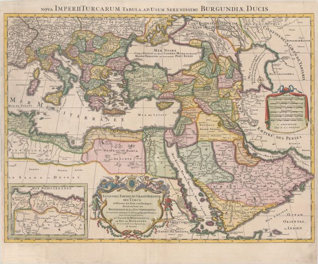
“Estats de l'Empire du Grand Seigneur des Turcs, en Europe, en Asie, et en Afrique, Divise en Tous ses Beglerbeglicz, ou Gouvernements...”
Map Maker:
Jaillot/Ottens
A large, decorative map of the Turkish Empire, cov... (full text available to subscribers)
| Item Detail |
| |
| |
MapMaker: |
Jaillot/Ottens
|
|
| |
| |
Subject: |
Eastern Mediterranean & Middle East |
|
| |
Period/Size: |
1740 / 17.9" x 24.3" (45.5 x 61.8 cm)
|
|
| |
Color: |
Colored
|
|
| |
Condition: |
(B+) A sharp impression with contemporary color in the map and later color in the cartouches. There are professional repairs to a long tear at left through the Mediterranean and into northern Africa, a 2" tear in Turkey, several separations along the cen (condition help) |
|
| |
Source: |
|
|
| |
References: |
|
|
| |
|
|
| Sales Information |
| |
| |
Price: |
|
|
| |
| |
Offered by: |
Old World Auctions |
|
| |
Catalog: |
Auction No. 182 - Antique Maps, Charts, Atlases & Globes (9528) |
|
| |
Lot/Item #: |
624 |
|
| |
| |
Date: |
04/2021
|
|
| |
| |
|
Antique Maps - Valuation and Pricing, Descriptions, Resources |
|
Home |
Information |
Search |
Register |
Contact Us |
Site Map
Americana Exchange, Inc. © 1999 - 2024 Americana Exchange, Inc.. All rights reserved.
OldMaps.com, the OldMaps.com logo and
AMPR are service marks or registered service marks of Americana Exchange, Inc..
|