Title:
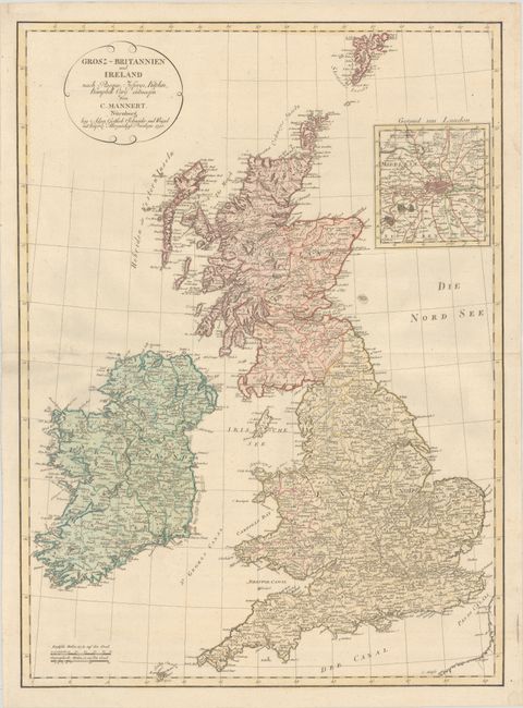
“Grosz-Britannien und Ireland nach Rocque, Jefferys, Kitchin, Kampbell Cary...”
Map Maker:
Conrad Mannert
This detailed map shows counties, towns, mountains... (full text available to subscribers)
| Item Detail |
| |
| |
MapMaker: |
Conrad Mannert
|
|
| |
| |
Subject: |
Britain |
|
| |
Period/Size: |
1795 / 29.0" x 20.9" (73.7 x 53.1 cm)
|
|
| |
Color: |
Colored
|
|
| |
Condition: |
(A) Contemporary color on a sturdy, watermarked sheet, issued folding with archival repairs to a separation at one of the fold intersections northwest of Ireland. (condition help) |
|
| |
Source: |
|
|
| |
References: |
|
|
| |
|
|
| Sales Information |
| |
| |
Price: |
|
|
| |
| |
Offered by: |
Old World Auctions |
|
| |
Catalog: |
Auction No. 183 - Antique Maps, Charts, Atlases & Globes (9529) |
|
| |
Lot/Item #: |
327 |
|
| |
| |
Date: |
06/2021
|
|
| |
| |
|
Antique Maps - Valuation and Pricing, Descriptions, Resources |
|
Home |
Information |
Search |
Register |
Contact Us |
Site Map
Americana Exchange, Inc. © 1999 - 2024 Americana Exchange, Inc.. All rights reserved.
OldMaps.com, the OldMaps.com logo and
AMPR are service marks or registered service marks of Americana Exchange, Inc..
|