Title:
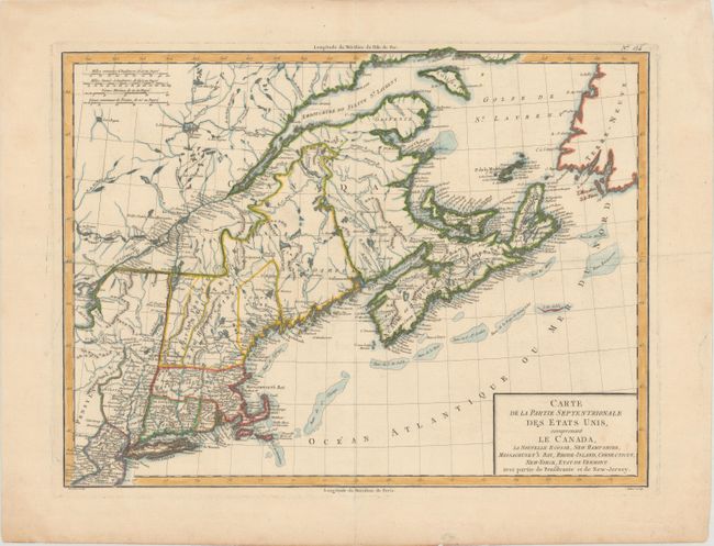
“Carte de la Partie Septentrionale des Etats Unis, Comprenant le Canada, la Nouvelle Ecosse, New Hampshire, Massachuset's Bay, Rhode-Island, Connecticut, New-Yorck, Etat de Vermont avec Partie de Pensilvanie et de New-Jersey”
Map Maker:
Pierre Francois Tardieu
Finely detailed map of the Northeast extending fro... (full text available to subscribers)
| Item Detail |
| |
| |
MapMaker: |
Pierre Francois Tardieu
|
|
| |
| |
Subject: |
Northeastern United States & Canada |
|
| |
Period/Size: |
1797 / 12.6" x 16.8" (32.0 x 42.7 cm)
|
|
| |
Color: |
Colored
|
|
| |
Condition: |
(A) Thick hand laid paper with wide, original margins and light damp stains along the edges of the sheet. Horizontal crease across center has been pressed and reinforced on verso with Japanese tissue. (condition help) |
|
| |
Source: |
Atlas Universel de Geographie Physique et Politique |
|
| |
References: |
McCorkle #797.5. |
|
| |
|
|
| Sales Information |
| |
| |
Price: |
|
|
| |
| |
Offered by: |
Old World Auctions |
|
| |
Catalog: |
Auction No. 183 - Antique Maps, Charts, Atlases & Globes (9529) |
|
| |
Lot/Item #: |
89 |
|
| |
| |
Date: |
06/2021
|
|
| |
| |
|
Antique Maps - Valuation and Pricing, Descriptions, Resources |
|
Home |
Information |
Search |
Register |
Contact Us |
Site Map
Americana Exchange, Inc. © 1999 - 2024 Americana Exchange, Inc.. All rights reserved.
OldMaps.com, the OldMaps.com logo and
AMPR are service marks or registered service marks of Americana Exchange, Inc..
|