Title:
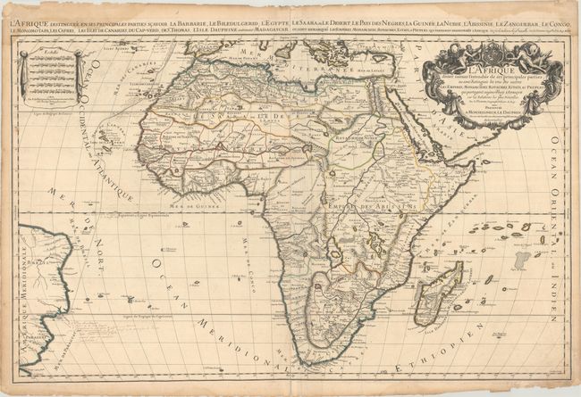
“L'Afrique Divisee Suivant l'Estendue de ses Principales Parties ou sont Distingues les uns des Autres les Empires, Monarchies, Royaumes, Estats, et Peuples...”
Map Maker:
Sanson/Jaillot
This striking map is the rare first state of Jaill... (full text available to subscribers)
| Item Detail |
| |
| |
MapMaker: |
Sanson/Jaillot
|
|
| |
| |
Subject: |
Africa |
|
| |
Period/Size: |
1674 / 21.6" x 35.0" (54.9 x 88.9 cm)
|
|
| |
Color: |
Colored
|
|
| |
Condition: |
(B) A dark impression on sheets with Society of Jesus watermarks, light soiling, extraneous creasing adjacent to the centerfold, and a centerfold separation at bottom that enters 1" into the image. There is a damp stain along the top edge of the sheet th (condition help) |
|
| |
Source: |
|
|
| |
References: |
Betz #118; Norwich #46; Tooley (AF) p.56, plt. #41. |
|
| |
|
|
| Sales Information |
| |
| |
Price: |
|
|
| |
| |
Offered by: |
Old World Auctions |
|
| |
Catalog: |
Auction No. 183 - Antique Maps, Charts, Atlases & Globes (9529) |
|
| |
Lot/Item #: |
499 |
|
| |
| |
Date: |
06/2021
|
|
| |
| |
|
Antique Maps - Valuation and Pricing, Descriptions, Resources |
|
Home |
Information |
Search |
Register |
Contact Us |
Site Map
Americana Exchange, Inc. © 1999 - 2024 Americana Exchange, Inc.. All rights reserved.
OldMaps.com, the OldMaps.com logo and
AMPR are service marks or registered service marks of Americana Exchange, Inc..
|