Title:
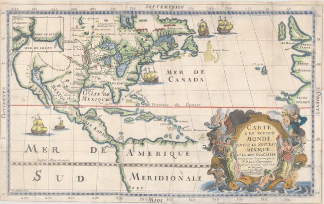
“Carte d'un Nouveau Monde, Entre le Nouveau Mexique, et la Mer Glacialle”
Map Maker:
Louis de Hennepin
This is an uncommon, updated version of Carte d... (full text available to subscribers)
| Item Detail |
| |
| |
MapMaker: |
Louis de Hennepin
|
|
| |
| |
Subject: |
Colonial North America |
|
| |
Period/Size: |
1698 / 11.5" x 18.4" (29.3 x 46.8 cm)
|
|
| |
Color: |
Colored
|
|
| |
Condition: |
(B) Issued folding on watermarked paper with numerous fold separations and short edge tears that have been repaired on verso with archival material. Minor surface soiling. (condition help) |
|
| |
Source: |
Nouvelle Voyage... |
|
| |
References: |
Burden #556; Phillips (Maps) p. 564. |
|
| |
|
|
| Sales Information |
| |
| |
Price: |
|
|
| |
| |
Offered by: |
Old World Auctions |
|
| |
Catalog: |
Auction No. 183 - Antique Maps, Charts, Atlases & Globes (9529) |
|
| |
Lot/Item #: |
60 |
|
| |
| |
Date: |
06/2021
|
|
| |
| |
|
Antique Maps - Valuation and Pricing, Descriptions, Resources |
|
Home |
Information |
Search |
Register |
Contact Us |
Site Map
Americana Exchange, Inc. © 1999 - 2024 Americana Exchange, Inc.. All rights reserved.
OldMaps.com, the OldMaps.com logo and
AMPR are service marks or registered service marks of Americana Exchange, Inc..
|