Title:
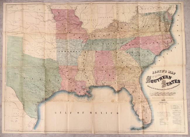
“Lloyd's Map of the Southern States Showing All the Railroads, Their Stations & Distances, Also the Counties Towns Villages Harbors Rivers and Forts...”
Map Maker:
James T. Lloyd
This is an early edition of this terrific Civil... (full text available to subscribers)
| Item Detail |
| |
| |
MapMaker: |
James T. Lloyd
|
|
| |
| |
Subject: |
Southern United States, Civil War |
|
| |
Period/Size: |
1861 / 37.1" x 52.0" (94.3 x 132.1 cm)
|
|
| |
Color: |
Colored
|
|
| |
Condition: |
(B) Issued folding with one small stain and numerous small fold separations that have been closed on verso with archival materials. There is minor loss at a few fold junctions and two small triangular areas of loss at the top and bottom centerfold that h (condition help) |
|
| |
Source: |
|
|
| |
References: |
Stephenson (Civil War) #14.25. |
|
| |
|
|
| Sales Information |
| |
| |
Price: |
|
|
| |
| |
Offered by: |
Old World Auctions |
|
| |
Catalog: |
Auction No. 183 - Antique Maps, Charts, Atlases & Globes (9529) |
|
| |
Lot/Item #: |
147 |
|
| |
| |
Date: |
06/2021
|
|
| |
| |
|
Antique Maps - Valuation and Pricing, Descriptions, Resources |
|
Home |
Information |
Search |
Register |
Contact Us |
Site Map
Americana Exchange, Inc. © 1999 - 2024 Americana Exchange, Inc.. All rights reserved.
OldMaps.com, the OldMaps.com logo and
AMPR are service marks or registered service marks of Americana Exchange, Inc..
|