Title:
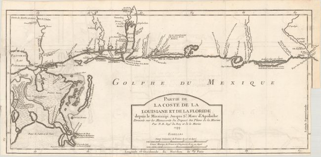
“Partie de la Coste de la Louisiane et de la Floride Depuis le Mississipi Jusqua St. Marc d'Apalache Dressee sur les Manuscrits du Depost des Plans de la Marine”
Map Maker:
Jacques Nicolas Bellin
This important early chart of the Gulf Coast cover... (full text available to subscribers)
| Item Detail |
| |
| |
MapMaker: |
Jacques Nicolas Bellin
|
|
| |
| |
Subject: |
Colonial Southern United States |
|
| |
Period/Size: |
1744 / 8.3" x 17.5" (21.1 x 44.5 cm)
|
|
| |
Color: |
Black & White
|
|
| |
Condition: |
(B) Issued folding on a bright sheet with light offsetting and a binding trim at lower right with partial loss of neatline. A 2" x 6" segment at left that detached has been skillfully rejoined with archival tape on verso. (condition help) |
|
| |
Source: |
Charlevoix's Histoire et Description Generale de la Nouvelle France |
|
| |
References: |
Tooley (MCC-96) #719. |
|
| |
|
|
| Sales Information |
| |
| |
Price: |
|
|
| |
| |
Offered by: |
Old World Auctions |
|
| |
Catalog: |
Auction No. 183 - Antique Maps, Charts, Atlases & Globes (9529) |
|
| |
Lot/Item #: |
144 |
|
| |
| |
Date: |
06/2021
|
|
| |
| |
|
Antique Maps - Valuation and Pricing, Descriptions, Resources |
|
Home |
Information |
Search |
Register |
Contact Us |
Site Map
Americana Exchange, Inc. © 1999 - 2024 Americana Exchange, Inc.. All rights reserved.
OldMaps.com, the OldMaps.com logo and
AMPR are service marks or registered service marks of Americana Exchange, Inc..
|