Title:
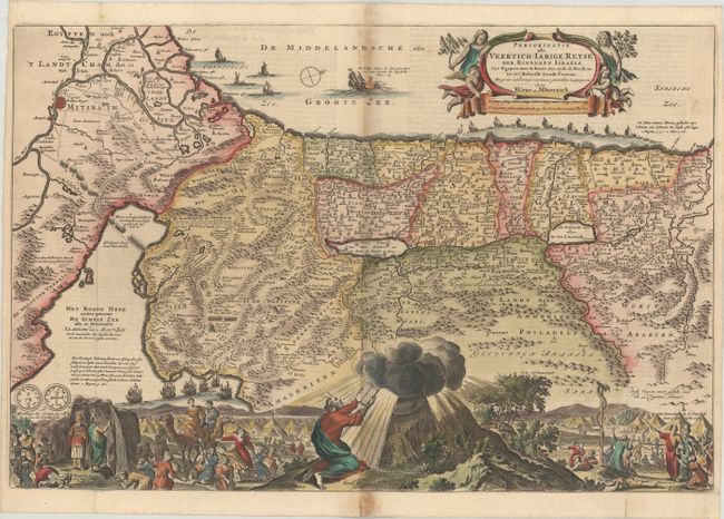
“Perigrinatie oste Veertich-Iarige Reyse der Kinderen Israels. Uyt Egypten door de Roode Zee, ende de Woestyne, tot in't Beloofde Landt Canaan...”
Map Maker:
Daniel Stoopendaal
This map depicts the Exodus from Egypt and the wan... (full text available to subscribers)
| Item Detail |
| |
| |
MapMaker: |
Daniel Stoopendaal
|
|
| |
| |
Subject: |
Holy Land |
|
| |
Period/Size: |
1690 / 12.1" x 18.2" (30.8 x 46.3 cm)
|
|
| |
Color: |
Colored
|
|
| |
Condition: |
(B+) A dark impression on a bright sheet, issued folding with two small worm holes in the image, light toning along the centerfold, and archival repairs to short fold separations at bottom. (condition help) |
|
| |
Source: |
|
|
| |
References: |
cf. Laor #807; Poortman & Augusteijn #140-KI. |
|
| |
|
|
| Sales Information |
| |
| |
Price: |
|
|
| |
| |
Offered by: |
Old World Auctions |
|
| |
Catalog: |
Auction No. 183 - Antique Maps, Charts, Atlases & Globes (9529) |
|
| |
Lot/Item #: |
458 |
|
| |
| |
Date: |
06/2021
|
|
| |
| |
|
Antique Maps - Valuation and Pricing, Descriptions, Resources |
|
Home |
Information |
Search |
Register |
Contact Us |
Site Map
Americana Exchange, Inc. © 1999 - 2024 Americana Exchange, Inc.. All rights reserved.
OldMaps.com, the OldMaps.com logo and
AMPR are service marks or registered service marks of Americana Exchange, Inc..
|