Title:
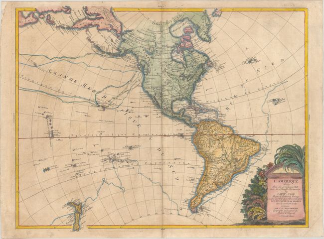
“L'Amerique Divisee dans les Principaux Etats avec les Nouvelles Decouvertes du Capit. Cook Depuis le Detroit de Behrings Jousqu' au Nord dans l'Ocean Pacifique et du Capit. Jean Meares dans les Annees 1788 et 1789”
Map Maker:
Charles Francois Delamarche
This large, rare map of the Americas extends to sh... (full text available to subscribers)
| Item Detail |
| |
| |
MapMaker: |
Charles Francois Delamarche
|
|
| |
| |
Subject: |
Western Hemisphere - America |
|
| |
Period/Size: |
1800 / 19.8" x 25.6" (50.3 x 65.1 cm)
|
|
| |
Color: |
Colored
|
|
| |
Condition: |
(B) Issued on watermarked paper with some light toning and soiling. The top right corner of the sheet is lightly creased. (condition help) |
|
| |
Source: |
|
|
| |
References: |
McGuirk #235. |
|
| |
|
|
| Sales Information |
| |
| |
Price: |
|
|
| |
| |
Offered by: |
Old World Auctions |
|
| |
Catalog: |
Auction No. 184 - Antique Maps, Charts, Atlases & Globes (9549) |
|
| |
Lot/Item #: |
94 |
|
| |
| |
Date: |
09/2021
|
|
| |
| |
|
Antique Maps - Valuation and Pricing, Descriptions, Resources |
|
Home |
Information |
Search |
Register |
Contact Us |
Site Map
Americana Exchange, Inc. © 1999 - 2024 Americana Exchange, Inc.. All rights reserved.
OldMaps.com, the OldMaps.com logo and
AMPR are service marks or registered service marks of Americana Exchange, Inc..
|