Title:
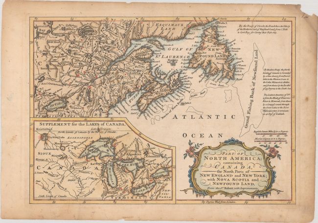
“Part of North America; Containing Canada, the North Parts of New England and New York; with Nova Scotia and Newfound Land. From the Sr. Robert with Improvements”
Map Maker:
Sir John Barrow
This beautifully engraved copper plate map, after ... (full text available to subscribers)
| Item Detail |
| |
| |
MapMaker: |
Sir John Barrow
|
|
| |
| |
Subject: |
Colonial Eastern United States & Canada, Great Lakes |
|
| |
Period/Size: |
1759 / 8.1" x 11.5" (20.6 x 29.3 cm)
|
|
| |
Color: |
Colored
|
|
| |
Condition: |
(B+) A crisp impression with light toning and foxing that is more prominent in the blank margins. There is a chip at top right and a tear that enters less than 1/2" into the image at top right that has been closed on verso with hinge tape. (condition help) |
|
| |
Source: |
New Geographical Dictionary |
|
| |
References: |
Kershaw #369; McCorkle #759.3. |
|
| |
|
|
| Sales Information |
| |
| |
Price: |
|
|
| |
| |
Offered by: |
Old World Auctions |
|
| |
Catalog: |
Auction No. 184 - Antique Maps, Charts, Atlases & Globes (9549) |
|
| |
Lot/Item #: |
139 |
|
| |
| |
Date: |
09/2021
|
|
| |
| |
|
Antique Maps - Valuation and Pricing, Descriptions, Resources |
|
Home |
Information |
Search |
Register |
Contact Us |
Site Map
Americana Exchange, Inc. © 1999 - 2024 Americana Exchange, Inc.. All rights reserved.
OldMaps.com, the OldMaps.com logo and
AMPR are service marks or registered service marks of Americana Exchange, Inc..
|