Title:
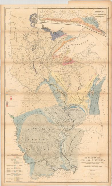
“Geological Map of Wisconsin, Iowa and Minnesota: Exhibiting, Also, the Extension of the Iowa Coal-Field Into Missouri, and Its Relation to the Illinois Coal-Field”
Map Maker:
David Dale Owen
This detailed and colorful geological map is from ... (full text available to subscribers)
| Item Detail |
| |
| |
MapMaker: |
David Dale Owen
|
|
| |
| |
Subject: |
Upper Midwestern United States |
|
| |
Period/Size: |
1851 / 44.0" x 26.3" (111.8 x 66.8 cm)
|
|
| |
Color: |
Colored
|
|
| |
Condition: |
(B) Issued folding with light toning, scattered foxing, and dampstains at right. (condition help) |
|
| |
Source: |
|
|
| |
References: |
Rumsey #0690. |
|
| |
|
|
| Sales Information |
| |
| |
Price: |
|
|
| |
| |
Offered by: |
Old World Auctions |
|
| |
Catalog: |
Auction No. 184 - Antique Maps, Charts, Atlases & Globes (9549) |
|
| |
Lot/Item #: |
232 |
|
| |
| |
Date: |
09/2021
|
|
| |
| |
|
Antique Maps - Valuation and Pricing, Descriptions, Resources |
|
Home |
Information |
Search |
Register |
Contact Us |
Site Map
Americana Exchange, Inc. © 1999 - 2024 Americana Exchange, Inc.. All rights reserved.
OldMaps.com, the OldMaps.com logo and
AMPR are service marks or registered service marks of Americana Exchange, Inc..
|