Title:
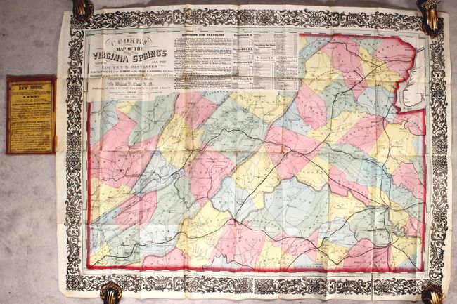
“Cooke's Map of the Routes to the Virginia Springs Giving All the Routes & Distances on the VA Central R.R. from Richmond...”
Map Maker:
William Dewey Cooke
This fascinating and rare pocket map was created t... (full text available to subscribers)
| Item Detail |
| |
| |
MapMaker: |
William Dewey Cooke
|
|
| |
| |
Subject: |
Virginia |
|
| |
Period/Size: |
1858 / 28.0" x 20.5" (71.2 x 52.1 cm)
|
|
| |
Color: |
Colored
|
|
| |
Condition: |
(B+) A superb impression with bold contemporary color on a bright sheet. There is very minor soiling and a 2" fold separation at bottom right. There are 7 small pieces of cello tape on verso closing short separations along fold intersections. Covers ar (condition help) |
|
| |
Source: |
|
|
| |
References: |
|
|
| |
|
|
| Sales Information |
| |
| |
Price: |
|
|
| |
| |
Offered by: |
Old World Auctions |
|
| |
Catalog: |
Auction No. 184 - Antique Maps, Charts, Atlases & Globes (9549) |
|
| |
Lot/Item #: |
349 |
|
| |
| |
Date: |
09/2021
|
|
| |
| |
|
Antique Maps - Valuation and Pricing, Descriptions, Resources |
|
Home |
Information |
Search |
Register |
Contact Us |
Site Map
Americana Exchange, Inc. © 1999 - 2024 Americana Exchange, Inc.. All rights reserved.
OldMaps.com, the OldMaps.com logo and
AMPR are service marks or registered service marks of Americana Exchange, Inc..
|