Title:
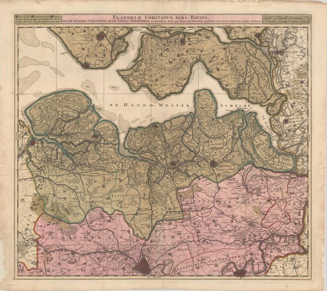
“Flandriae Comitatus Pars Batava, tam in Ejusdem Subjacentia quam Vicina Territoria...”
Map Maker:
Nicolas Visscher
This elegantly engraved map of the historical regi... (full text available to subscribers)
| Item Detail |
| |
| |
MapMaker: |
Nicolas Visscher
|
|
| |
| |
Subject: |
Northwestern Belgium & Southwestern Netherlands |
|
| |
Period/Size: |
1700 / 19.4" x 21.7" (49.3 x 55.2 cm)
|
|
| |
Color: |
Colored
|
|
| |
Condition: |
(B) A sharp impression in contemporary color with a number of cracks in the green pigment due to oxidation, several of which have been closed on verso with tissue and linen tape. There are two repaired fold separations and chipping in the left and right (condition help) |
|
| |
Source: |
|
|
| |
References: |
|
|
| |
|
|
| Sales Information |
| |
| |
Price: |
|
|
| |
| |
Offered by: |
Old World Auctions |
|
| |
Catalog: |
Auction No. 184 - Antique Maps, Charts, Atlases & Globes (9549) |
|
| |
Lot/Item #: |
483 |
|
| |
| |
Date: |
09/2021
|
|
| |
| |
|
Antique Maps - Valuation and Pricing, Descriptions, Resources |
|
Home |
Information |
Search |
Register |
Contact Us |
Site Map
Americana Exchange, Inc. © 1999 - 2024 Americana Exchange, Inc.. All rights reserved.
OldMaps.com, the OldMaps.com logo and
AMPR are service marks or registered service marks of Americana Exchange, Inc..
|