Title:
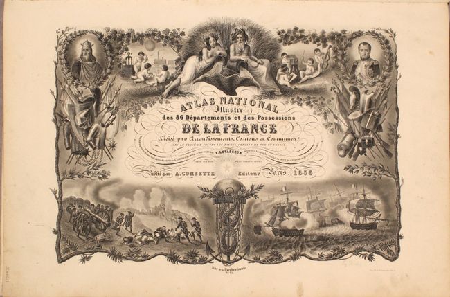
“Atlas National Illustre des 86 Departements et des Possessions de la France Divise par Arrondissements, Cantons et Communes...”
Map Maker:
Victor Levasseur
This was one of the last decorative atlases ever p... (full text available to subscribers)
| Item Detail |
| |
| |
MapMaker: |
Victor Levasseur
|
|
| |
| |
Subject: |
France, Atlas |
|
| |
Period/Size: |
1856 / 21.0" x 14.3" (53.4 x 36.4 cm)
|
|
| |
Color: |
Colored
|
|
| |
Condition: |
(B+) The maps are near fine with contemporary outline color and occasional minor soiling in the margins. Title page is partially detached with an old stamp in the top corner on verso. Front hinge is starting. Covers are partially sunned with shelf wear (condition help) |
|
| |
Source: |
|
|
| |
References: |
|
|
| |
|
|
| Sales Information |
| |
| |
Price: |
|
|
| |
| |
Offered by: |
Old World Auctions |
|
| |
Catalog: |
Auction No. 184 - Antique Maps, Charts, Atlases & Globes (9549) |
|
| |
Lot/Item #: |
486 |
|
| |
| |
Date: |
09/2021
|
|
| |
| |
|
Antique Maps - Valuation and Pricing, Descriptions, Resources |
|
Home |
Information |
Search |
Register |
Contact Us |
Site Map
Americana Exchange, Inc. © 1999 - 2024 Americana Exchange, Inc.. All rights reserved.
OldMaps.com, the OldMaps.com logo and
AMPR are service marks or registered service marks of Americana Exchange, Inc..
|