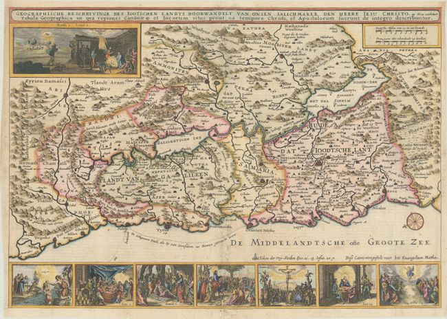
Title:
“Geographische Beschryvinge des Iootschen Landts Doorwandelt van Onsen Salichmaker den Heere Iesu Christo...”
Map Maker:
Cornelius Danckerts
This is a fine Bible map of the Holy Land with nor... (full text available to subscribers)
| Item Detail |
| |
| |
MapMaker: |
Cornelius Danckerts
|
|
| |
| |
Subject: |
Holy Land |
|
| |
Period/Size: |
1646 / 13.4" x 19.2" (34.1 x 48.8 cm)
|
|
| |
Color: |
Colored
|
|
| |
Condition: |
(B+) A darg impression on a bright sheet with a coat of arms watermark and some light soiling along the centerfold at bottom. There are professional repairs to some separations along the centerfold and to a few small holes in the bottom blank margin. (condition help) |
|
| |
Source: |
|
|
| |
References: |
Poortman & Augusteijn #105. |
|
| |
|
|
| Sales Information |
| |
| |
Price: |
|
|
| |
| |
Offered by: |
Old World Auctions |
|
| |
Catalog: |
Auction No. 184 - Antique Maps, Charts, Atlases & Globes (9549) |
|
| |
Lot/Item #: |
631 |
|
| |
| |
Date: |
09/2021
|
|
| |
| |
|
Antique Maps - Valuation and Pricing, Descriptions, Resources |
|
Home |
Information |
Search |
Register |
Contact Us |
Site Map
Americana Exchange, Inc. © 1999 - 2024 Americana Exchange, Inc.. All rights reserved.
OldMaps.com, the OldMaps.com logo and
AMPR are service marks or registered service marks of Americana Exchange, Inc..
|