Title:
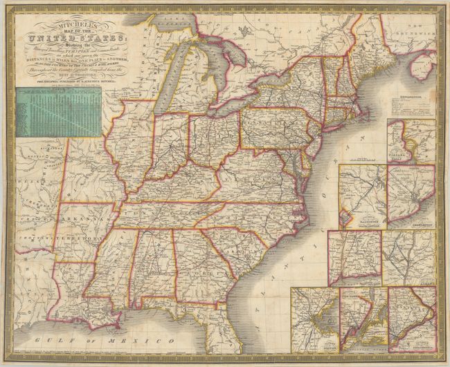
“Mitchell's Map of the United States; Showing the Principal Travelling, Turnpike and Common Roads; on Which Are Given the Distances in Miles from One Place to Another...”
Map Maker:
Samuel Augustus Mitchell
This uncommon pocket map shows the United States w... (full text available to subscribers)
| Item Detail |
| |
| |
MapMaker: |
Samuel Augustus Mitchell
|
|
| |
| |
Subject: |
Eastern United States |
|
| |
Period/Size: |
1836 / 18.9" x 23.3" (48.0 x 59.2 cm)
|
|
| |
Color: |
Colored
|
|
| |
Condition: |
(B+) Issued folding with light scattered foxing and a number of short fold separations that have been professionally repaired on verso. Encased in Mylar for preservation. (condition help) |
|
| |
Source: |
|
|
| |
References: |
Phillips (Maps) p. 889. |
|
| |
|
|
| Sales Information |
| |
| |
Price: |
|
|
| |
| |
Offered by: |
Old World Auctions |
|
| |
Catalog: |
Auction No. 185 - Antique Maps, Charts, Atlases & Globes (9550) |
|
| |
Lot/Item #: |
189 |
|
| |
| |
Date: |
11/2021
|
|
| |
| |
|
Antique Maps - Valuation and Pricing, Descriptions, Resources |
|
Home |
Information |
Search |
Register |
Contact Us |
Site Map
Americana Exchange, Inc. © 1999 - 2024 Americana Exchange, Inc.. All rights reserved.
OldMaps.com, the OldMaps.com logo and
AMPR are service marks or registered service marks of Americana Exchange, Inc..
|