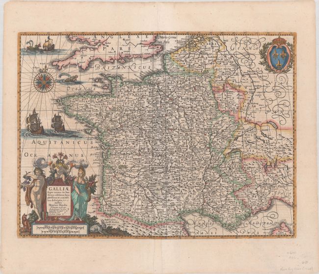
Title:
“Galliae Supra Omnes in hac Forma Editiones Locu Pletissima et Exactissima Descriptio”
Map Maker:
Henricus Hondius
This is the rare English issue of this supe... (full text available to subscribers)
| Item Detail |
| |
| |
MapMaker: |
Henricus Hondius
|
|
| |
| |
Subject: |
France |
|
| |
Period/Size: |
1631 / 14.6" x 19.6" (37.1 x 49.8 cm)
|
|
| |
Color: |
Colored
|
|
| |
Condition: |
(B) A sharp impression with separations along the centerfold that have been repaired on verso with archival material. A small section of the map along the lower centerfold and a portion of the bottom border have been replaced in facsimile. (condition help) |
|
| |
Source: |
Atlas or A Geographicke Description... |
|
| |
References: |
Van der Krogt (Vol. I) #4000:1E.2. |
|
| |
|
|
| Sales Information |
| |
| |
Price: |
|
|
| |
| |
Offered by: |
Old World Auctions |
|
| |
Catalog: |
Auction No. 185 - Antique Maps, Charts, Atlases & Globes (9550) |
|
| |
Lot/Item #: |
496 |
|
| |
| |
Date: |
11/2021
|
|
| |
| |
|
Antique Maps - Valuation and Pricing, Descriptions, Resources |
|
Home |
Information |
Search |
Register |
Contact Us |
Site Map
Americana Exchange, Inc. © 1999 - 2024 Americana Exchange, Inc.. All rights reserved.
OldMaps.com, the OldMaps.com logo and
AMPR are service marks or registered service marks of Americana Exchange, Inc..
|