Title:
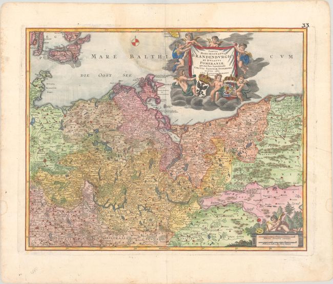
“Tabula Marchionatus Brandenburgici et Ducatus Pomeraniae quae sunt Pars Septentrionalis Circuli Saxoniae Superioris Novissime Edita”
Map Maker:
Johann Baptist Homann
The area of northeast Germany and western Poland i... (full text available to subscribers)
| Item Detail |
| |
| |
MapMaker: |
Johann Baptist Homann
|
|
| |
| |
Subject: |
Northeast Germany & Western Poland |
|
| |
Period/Size: |
1716 / 16.8" x 21.3" (42.7 x 54.1 cm)
|
|
| |
Color: |
Colored
|
|
| |
Condition: |
(B) A bright sheet of watermarked paper with light soiling and a large, faint dampstain at top center. There are some tiny tears and couple of additional small dampstains along the edge of the sheet. (condition help) |
|
| |
Source: |
|
|
| |
References: |
|
|
| |
|
|
| Sales Information |
| |
| |
Price: |
|
|
| |
| |
Offered by: |
Old World Auctions |
|
| |
Catalog: |
Auction No. 185 - Antique Maps, Charts, Atlases & Globes (9550) |
|
| |
Lot/Item #: |
529 |
|
| |
| |
Date: |
11/2021
|
|
| |
| |
|
Antique Maps - Valuation and Pricing, Descriptions, Resources |
|
Home |
Information |
Search |
Register |
Contact Us |
Site Map
Americana Exchange, Inc. © 1999 - 2024 Americana Exchange, Inc.. All rights reserved.
OldMaps.com, the OldMaps.com logo and
AMPR are service marks or registered service marks of Americana Exchange, Inc..
|