Title:
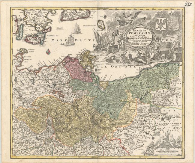
“Ducatus Pomeraniae cum Magna Maris Balthici et Provinciarum ad Nexarum Parte ad Delineationem Novissimam...”
Map Maker:
Matthias Seutter
This handsome German map centers on the Szczecin L... (full text available to subscribers)
| Item Detail |
| |
| |
MapMaker: |
Matthias Seutter
|
|
| |
| |
Subject: |
Eastern Germany & Western Poland |
|
| |
Period/Size: |
1730 / 19.4" x 22.2" (49.3 x 56.4 cm)
|
|
| |
Color: |
Colored
|
|
| |
Condition: |
(A) A sharp impression with full contemporary color on a bright sheet with some minor creasing at top center and marginal soiling and foxing. (condition help) |
|
| |
Source: |
|
|
| |
References: |
|
|
| |
|
|
| Sales Information |
| |
| |
Price: |
|
|
| |
| |
Offered by: |
Old World Auctions |
|
| |
Catalog: |
Auction No. 185 - Antique Maps, Charts, Atlases & Globes (9550) |
|
| |
Lot/Item #: |
530 |
|
| |
| |
Date: |
11/2021
|
|
| |
| |
|
Antique Maps - Valuation and Pricing, Descriptions, Resources |
|
Home |
Information |
Search |
Register |
Contact Us |
Site Map
Americana Exchange, Inc. © 1999 - 2024 Americana Exchange, Inc.. All rights reserved.
OldMaps.com, the OldMaps.com logo and
AMPR are service marks or registered service marks of Americana Exchange, Inc..
|