Title:
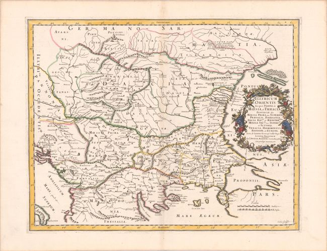
“Illyricum Orientis in quo, Partes, II Moesia, et Thracia Provinciae XI. Moesia Prima, sive Superior, Praevalis Dardania...”
Map Maker:
N. Sanson/Mariette
An attractive historical map of the area between t... (full text available to subscribers)
| Item Detail |
| |
| |
MapMaker: |
N. Sanson/Mariette
|
|
| |
| |
Subject: |
Balkans |
|
| |
Period/Size: |
1667 / 16.3" x 20.8" (41.4 x 52.9 cm)
|
|
| |
Color: |
Colored
|
|
| |
Condition: |
(B+) A dark impression with contemporary outline color in the map and later color in the cartouche, on a bright sheet with the watermarks of a large coat of arms and the symbol for the Society of Jesus, and very light toning along the centerfold. (condition help) |
|
| |
Source: |
Cartes Generales de Toutes les Parties du Monde... |
|
| |
References: |
Pastoureau, SANSON V B [163]. |
|
| |
|
|
| Sales Information |
| |
| |
Price: |
|
|
| |
| |
Offered by: |
Old World Auctions |
|
| |
Catalog: |
Auction No. 185 - Antique Maps, Charts, Atlases & Globes (9550) |
|
| |
Lot/Item #: |
568 |
|
| |
| |
Date: |
11/2021
|
|
| |
| |
|
Antique Maps - Valuation and Pricing, Descriptions, Resources |
|
Home |
Information |
Search |
Register |
Contact Us |
Site Map
Americana Exchange, Inc. © 1999 - 2024 Americana Exchange, Inc.. All rights reserved.
OldMaps.com, the OldMaps.com logo and
AMPR are service marks or registered service marks of Americana Exchange, Inc..
|