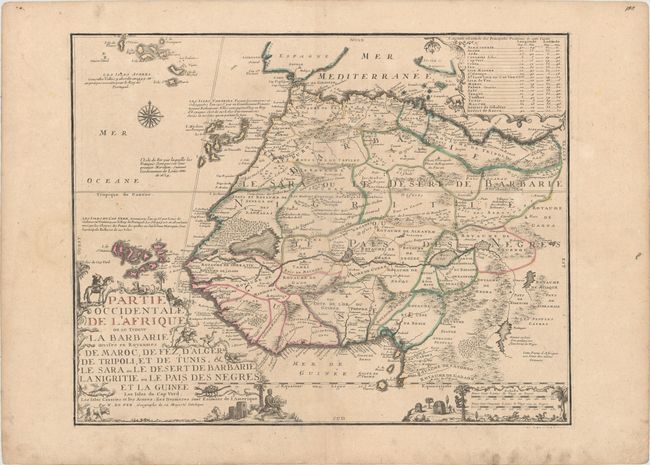
Title:
“Partie Occidentale de l'Afrique ou se Trouve la Barbarie Divisee en Royaumes...”
Map Maker:
Nicholas de Fer
This uncommon, large-format map of Africa is fille... (full text available to subscribers)
| Item Detail |
| |
| |
MapMaker: |
Nicholas de Fer
|
|
| |
| |
Subject: |
Northwestern Africa |
|
| |
Period/Size: |
1709 / 18.5" x 23.4" (47.0 x 59.5 cm)
|
|
| |
Color: |
Colored
|
|
| |
Condition: |
(B+) A nice impression with contemporary outline color on wide margined paper with the watermark of a Maltese cross encircled in rosary beads. There is light soiling and a professionally repaired centerfold separation at bottom. (condition help) |
|
| |
Source: |
Atlas ou Recueil de Cartes Geographiques |
|
| |
References: |
Pastoureau, FER II C [92]. |
|
| |
|
|
| Sales Information |
| |
| |
Price: |
|
|
| |
| |
Offered by: |
Old World Auctions |
|
| |
Catalog: |
Auction No. 185 - Antique Maps, Charts, Atlases & Globes (9550) |
|
| |
Lot/Item #: |
707 |
|
| |
| |
Date: |
11/2021
|
|
| |
| |
|
Antique Maps - Valuation and Pricing, Descriptions, Resources |
|
Home |
Information |
Search |
Register |
Contact Us |
Site Map
Americana Exchange, Inc. © 1999 - 2024 Americana Exchange, Inc.. All rights reserved.
OldMaps.com, the OldMaps.com logo and
AMPR are service marks or registered service marks of Americana Exchange, Inc..
|