Title:
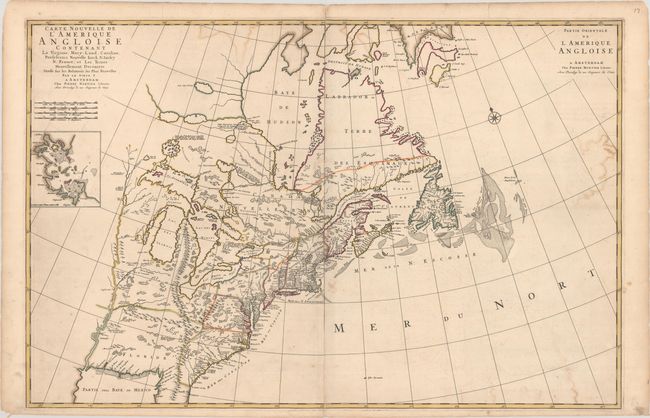
“Carte Nouvelle de l'Amerique Angloise Contenant la Virginie, Mary-Land, Caroline, Pensylvania Nouvelle Iorck, N: Iarsey N: France, et les Terres Nouvellement Decouerte...”
Map Maker:
Pierre Mortier
This large, interesting map is filled with various... (full text available to subscribers)
| Item Detail |
| |
| |
MapMaker: |
Pierre Mortier
|
|
| |
| |
Subject: |
Colonial Eastern United States & Canada |
|
| |
Period/Size: |
1700 / 23.4" x 35.8" (59.5 x 91.0 cm)
|
|
| |
Color: |
Colored
|
|
| |
Condition: |
(B+) A fine impression with contemporary outline color and some color offsetting. There are two short cracks and one tiny hole (along the eastern border of Nouvelle Angleterre) that have been closed on verso with archival tape. (condition help) |
|
| |
Source: |
Suite de Neptune Francois |
|
| |
References: |
Burden #765; Cumming (SE) #129; McCorkle #695.7. |
|
| |
|
|
| Sales Information |
| |
| |
Price: |
|
|
| |
| |
Offered by: |
Old World Auctions |
|
| |
Catalog: |
Auction No. 186 - Antique Maps, Charts, Atlases & Globes (9551) |
|
| |
Lot/Item #: |
130 |
|
| |
| |
Date: |
02/2022
|
|
| |
| |
|
Antique Maps - Valuation and Pricing, Descriptions, Resources |
|
Home |
Information |
Search |
Register |
Contact Us |
Site Map
Americana Exchange, Inc. © 1999 - 2024 Americana Exchange, Inc.. All rights reserved.
OldMaps.com, the OldMaps.com logo and
AMPR are service marks or registered service marks of Americana Exchange, Inc..
|