Title:
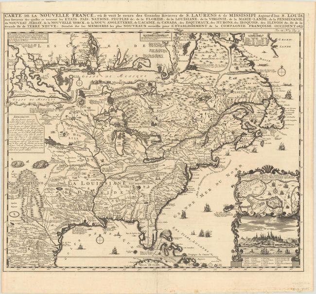
“Carte de la Nouvelle France, ou se voit le Cours des Grandes Rivieres de S. Laurens & de Mississipi Aujour d'hui S. Louis, aux Environs des-quelles se Trouvent les Etats, Pais, Nations, Peuples &c...”
Map Maker:
Henry Abraham Chatelain
Derived from Nicholas de Fer's important four-shee... (full text available to subscribers)
| Item Detail |
| |
| |
MapMaker: |
Henry Abraham Chatelain
|
|
| |
| |
Subject: |
Colonial Eastern United States & Canada |
|
| |
Period/Size: |
1720 / 16.6" x 19.3" (42.2 x 49.1 cm)
|
|
| |
Color: |
Black & White
|
|
| |
Condition: |
(A) A dark impression on a bright sheet with a Strasburg bend & lily watermark, issue folding, with a centerfold separation at bottom and a few short tears adjacent to the centerfold that have been professionally repaired. Narrow left margin, as issued. (condition help) |
|
| |
Source: |
Atlas Historique |
|
| |
References: |
Kershaw #332; McCorkle #719.4; Verner and Stuart-Stubbs #11. |
|
| |
|
|
| Sales Information |
| |
| |
Price: |
|
|
| |
| |
Offered by: |
Old World Auctions |
|
| |
Catalog: |
Auction No. 186 - Antique Maps, Charts, Atlases & Globes (9551) |
|
| |
Lot/Item #: |
131 |
|
| |
| |
Date: |
02/2022
|
|
| |
| |
|
Antique Maps - Valuation and Pricing, Descriptions, Resources |
|
Home |
Information |
Search |
Register |
Contact Us |
Site Map
Americana Exchange, Inc. © 1999 - 2024 Americana Exchange, Inc.. All rights reserved.
OldMaps.com, the OldMaps.com logo and
AMPR are service marks or registered service marks of Americana Exchange, Inc..
|