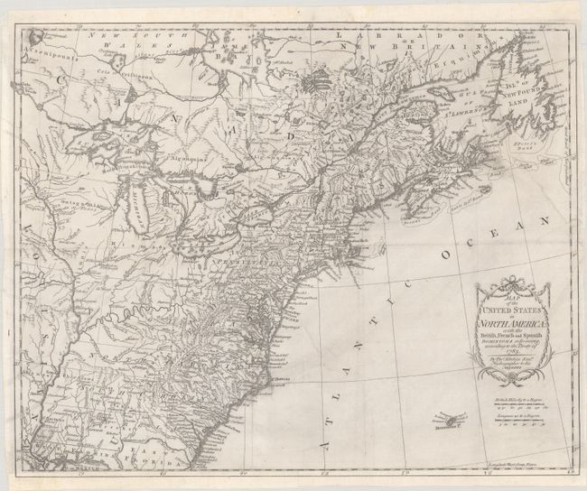
Title:
“Map of the United States in North America: with the British, French and Spanish Dominions Adjoining, According to the Treaty of 1783”
Map Maker:
Thomas Kitchin
This is one of the earliest English-produced ma... (full text available to subscribers)
| Item Detail |
| |
| |
MapMaker: |
Thomas Kitchin
|
|
| |
| |
Subject: |
Eastern United States & Canada |
|
| |
Period/Size: |
1783 / 16.1" x 19.9" (40.9 x 50.6 cm)
|
|
| |
Color: |
Black & White
|
|
| |
Condition: |
(B) A nice impression issued folding, now flat, with light soiling. The margins were trimmed at top left and bottom and have been professionally replaced, with sections of neatline and border now in facsimile. 4" and 2" edge tears at right have been clo (condition help) |
|
| |
Source: |
|
|
| |
References: |
McCorkle #783-11; Phillips (M) p. 862. |
|
| |
|
|
| Sales Information |
| |
| |
Price: |
|
|
| |
| |
Offered by: |
Old World Auctions |
|
| |
Catalog: |
Auction No. 186 - Antique Maps, Charts, Atlases & Globes (9551) |
|
| |
Lot/Item #: |
135 |
|
| |
| |
Date: |
02/2022
|
|
| |
| |
|
Antique Maps - Valuation and Pricing, Descriptions, Resources |
|
Home |
Information |
Search |
Register |
Contact Us |
Site Map
Americana Exchange, Inc. © 1999 - 2024 Americana Exchange, Inc.. All rights reserved.
OldMaps.com, the OldMaps.com logo and
AMPR are service marks or registered service marks of Americana Exchange, Inc..
|