Title:
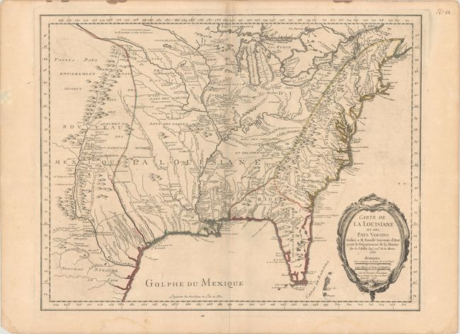
“Carte de la Louisiane et des Pays Voisins Dediee a M. Rouille Secretaire d'Etat, Ayant le Departement de la Marine”
Map Maker:
Jacques Nicolas Bellin
This scarce French and Indian War-era map c... (full text available to subscribers)
| Item Detail |
| |
| |
MapMaker: |
Jacques Nicolas Bellin
|
|
| |
| |
Subject: |
Colonial Eastern United States |
|
| |
Period/Size: |
1755 / 18.8" x 24.1" (47.8 x 61.3 cm)
|
|
| |
Color: |
Colored
|
|
| |
Condition: |
(B+) A nice impression on a sheet with the watermark of a Maltese cross encircled in rosary beads. There is light toning that is a bit more apparent along the centerfold, minor offsetting, and light dampstains that are confined to the blank margins. (condition help) |
|
| |
Source: |
|
|
| |
References: |
Lowery #406; McCorkle #755.3; MCC-96 #689. |
|
| |
|
|
| Sales Information |
| |
| |
Price: |
|
|
| |
| |
Offered by: |
Old World Auctions |
|
| |
Catalog: |
Auction No. 186 - Antique Maps, Charts, Atlases & Globes (9551) |
|
| |
Lot/Item #: |
171 |
|
| |
| |
Date: |
02/2022
|
|
| |
| |
|
Antique Maps - Valuation and Pricing, Descriptions, Resources |
|
Home |
Information |
Search |
Register |
Contact Us |
Site Map
Americana Exchange, Inc. © 1999 - 2024 Americana Exchange, Inc.. All rights reserved.
OldMaps.com, the OldMaps.com logo and
AMPR are service marks or registered service marks of Americana Exchange, Inc..
|