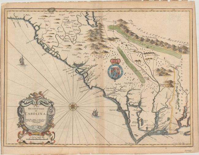
Title:
“A New Description of Carolina”
Map Maker:
John Speed/Francis Lamb
This striking map of the Southeast region was base... (full text available to subscribers)
| Item Detail |
| |
| |
MapMaker: |
John Speed/Francis Lamb
|
|
| |
| |
Subject: |
Colonial Southeast United States |
|
| |
Period/Size: |
1676 / 14.9" x 20.1" (37.9 x 51.1 cm)
|
|
| |
Color: |
Colored
|
|
| |
Condition: |
(B) A nice impression on a sheet with a small fleur-de-lis watermark and toning along the centerfold and edges of the sheet. There are archival tissue repairs to a small worm track along the centerfold at bottom and a short centerfold separation also at (condition help) |
|
| |
Source: |
A Prospect of the Most Famous Parts of the World |
|
| |
References: |
Cumming (SE) #77; Goss (NA) #41; Shirley (BL Atlases) T.SPE-2f #26. |
|
| |
|
|
| Sales Information |
| |
| |
Price: |
|
|
| |
| |
Offered by: |
Old World Auctions |
|
| |
Catalog: |
Auction No. 186 - Antique Maps, Charts, Atlases & Globes (9551) |
|
| |
Lot/Item #: |
208 |
|
| |
| |
Date: |
02/2022
|
|
| |
| |
|
Antique Maps - Valuation and Pricing, Descriptions, Resources |
|
Home |
Information |
Search |
Register |
Contact Us |
Site Map
Americana Exchange, Inc. © 1999 - 2024 Americana Exchange, Inc.. All rights reserved.
OldMaps.com, the OldMaps.com logo and
AMPR are service marks or registered service marks of Americana Exchange, Inc..
|