| Item Detail |
| |
| |
MapMaker: |
(none given)
|
|
| |
| |
Subject: |
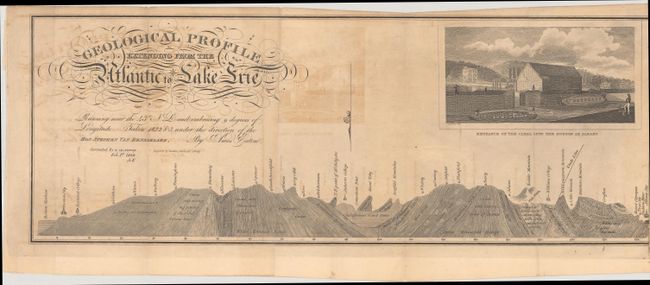
New York, Erie Canal |
|
| |
Period/Size: |
1828 / 7.0" x 56.2" (17.8 x 142.8 cm)
|
|
| |
Color: |
Black & White
|
|
| |
Condition: |
(B) Issued folding with some light offsetting and staining at the joints from the adhesive used to join the paper. There are a couple of small fold separations that have been closed on verso with archival tape. (condition help) |
|
| |
Source: |
|
|
| |
References: |
|
|
| |
|
|
| Sales Information |
| |
| |
Price: |
|
|
| |
| |
Offered by: |
Old World Auctions |
|
| |
Catalog: |
Auction No. 186 - Antique Maps, Charts, Atlases & Globes (9551) |
|
| |
Lot/Item #: |
292 |
|
| |
| |
Date: |
02/2022
|
|
| |
| |
|