Title:
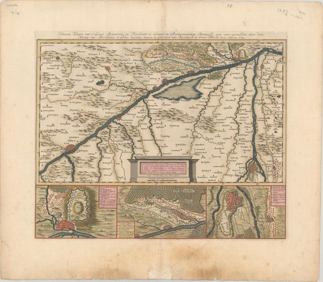
“Nouvelle Carte du Pais de Donawert et Hochstett &c. ou la Memorable Bataille... / Nieuwe Kaart, van t' Land Donawert, en Hochstett &c. Alwaar de Roemwaardige Battaille...”
Map Maker:
Nicolas Visscher
This detailed map shows the region between Ulm, Do... (full text available to subscribers)
| Item Detail |
| |
| |
MapMaker: |
Nicolas Visscher
|
|
| |
| |
Subject: |
Southern Germany |
|
| |
Period/Size: |
1704 / 14.8" x 18.6" (37.6 x 47.3 cm)
|
|
| |
Color: |
Colored
|
|
| |
Condition: |
(B+) A crisp impression with contemporary color on a watermarked sheet with soiling in the bottom margin. There are a few chips and tears in the bottom blank margin that have been partially repaired with old paper. (condition help) |
|
| |
Source: |
Variae Tabulae Geographicae in Quibus Loca in Orbe Bello... |
|
| |
References: |
Phillips (Atlases) #3387-19. |
|
| |
|
|
| Sales Information |
| |
| |
Price: |
|
|
| |
| |
Offered by: |
Old World Auctions |
|
| |
Catalog: |
Auction No. 186 - Antique Maps, Charts, Atlases & Globes (9551) |
|
| |
Lot/Item #: |
510 |
|
| |
| |
Date: |
02/2022
|
|
| |
| |
|
Antique Maps - Valuation and Pricing, Descriptions, Resources |
|
Home |
Information |
Search |
Register |
Contact Us |
Site Map
Americana Exchange, Inc. © 1999 - 2024 Americana Exchange, Inc.. All rights reserved.
OldMaps.com, the OldMaps.com logo and
AMPR are service marks or registered service marks of Americana Exchange, Inc..
|