Title:
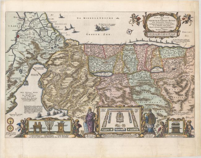
“Perigrinatie ofte Veertich-Iarige Reyse der Kinderen Israels, uyt Egypten door de Roode Zee, ende de Woestyne, tot in't Beloofde Landt Canaan...”
Map Maker:
Nicolas Visscher
This lavishly decorated map of the Holy Land depic... (full text available to subscribers)
| Item Detail |
| |
| |
MapMaker: |
Nicolas Visscher
|
|
| |
| |
Subject: |
Holy Land |
|
| |
Period/Size: |
1661 / 12.5" x 18.8" (31.8 x 47.8 cm)
|
|
| |
Color: |
Colored
|
|
| |
Condition: |
(B+) A crisp early impression with professional repairs to fold separations that are mostly confined to the blank margins. Remargined at left and right with small portions of the neatline replaced in facsimile. (condition help) |
|
| |
Source: |
|
|
| |
References: |
Laor #795; Poortman & Augusteijn #120. |
|
| |
|
|
| Sales Information |
| |
| |
Price: |
|
|
| |
| |
Offered by: |
Old World Auctions |
|
| |
Catalog: |
Auction No. 186 - Antique Maps, Charts, Atlases & Globes (9551) |
|
| |
Lot/Item #: |
640 |
|
| |
| |
Date: |
02/2022
|
|
| |
| |
|
Antique Maps - Valuation and Pricing, Descriptions, Resources |
|
Home |
Information |
Search |
Register |
Contact Us |
Site Map
Americana Exchange, Inc. © 1999 - 2024 Americana Exchange, Inc.. All rights reserved.
OldMaps.com, the OldMaps.com logo and
AMPR are service marks or registered service marks of Americana Exchange, Inc..
|