Title:
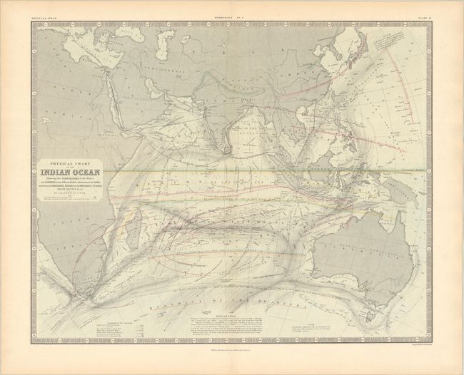
“Physical Chart of the Indian Ocean Showing the Temperature of the Water, the Currents of the Air and Ocean, Directions of the Wind, Districts of Hurricanes...”
Map Maker:
W. & A.K. Johnston
This detailed chart covers the entire Indian Ocean... (full text available to subscribers)
| Item Detail |
| |
| |
MapMaker: |
W. & A.K. Johnston
|
|
| |
| |
Subject: |
Indian Ocean |
|
| |
Period/Size: |
1855 / 18.8" x 23.3" (47.8 x 59.2 cm)
|
|
| |
Color: |
Colored
|
|
| |
Condition: |
(A) On a sturdy clean sheet with a short centerfold separation confined to the bottom blank margin that has been closed on verso with paper tape. (condition help) |
|
| |
Source: |
The Physical Atlas of Natural Phenomena |
|
| |
References: |
Phillips (Atlases) #229. |
|
| |
|
|
| Sales Information |
| |
| |
Price: |
|
|
| |
| |
Offered by: |
Old World Auctions |
|
| |
Catalog: |
Auction No. 186 - Antique Maps, Charts, Atlases & Globes (9551) |
|
| |
Lot/Item #: |
699 |
|
| |
| |
Date: |
02/2022
|
|
| |
| |
|
Antique Maps - Valuation and Pricing, Descriptions, Resources |
|
Home |
Information |
Search |
Register |
Contact Us |
Site Map
Americana Exchange, Inc. © 1999 - 2024 Americana Exchange, Inc.. All rights reserved.
OldMaps.com, the OldMaps.com logo and
AMPR are service marks or registered service marks of Americana Exchange, Inc..
|