Title:
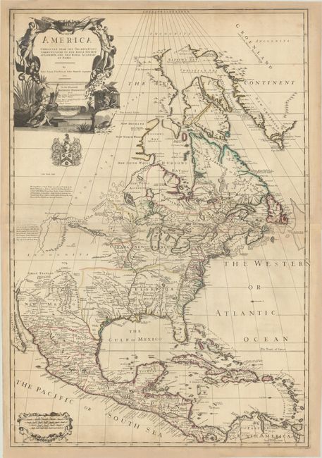
“North America Corrected from the Observations Communicated to the Royal Society at London, and the Royal Academy at Paris”
Map Maker:
Price, Senex & Maxwell
This striking map is based largely on Delisle's ca... (full text available to subscribers)
| Item Detail |
| |
| |
MapMaker: |
Price, Senex & Maxwell
|
|
| |
| |
Subject: |
Colonial North America |
|
| |
Period/Size: |
1710 / 37.7" x 25.8" (95.8 x 65.6 cm)
|
|
| |
Color: |
Colored
|
|
| |
Condition: |
(B+) A sharp impression with contemporary outline color on sheets with large fleur-de-lis coat of arms watermarks. The map has been professionally remargined to repair several chips along the sheets' edges. There is light toning along the joint and a bi (condition help) |
|
| |
Source: |
|
|
| |
References: |
Phillips (Maps) p. 566; Tooley (Amer) p. 91, #61; cf. Wheat (TMW) #92. |
|
| |
|
|
| Sales Information |
| |
| |
Price: |
|
|
| |
| |
Offered by: |
Old World Auctions |
|
| |
Catalog: |
Auction No. 187 - Antique Maps, Charts, Atlases & Globes (9557) |
|
| |
Lot/Item #: |
97 |
|
| |
| |
Date: |
02/2022
|
|
| |
| |
|
Antique Maps - Valuation and Pricing, Descriptions, Resources |
|
Home |
Information |
Search |
Register |
Contact Us |
Site Map
Americana Exchange, Inc. © 1999 - 2024 Americana Exchange, Inc.. All rights reserved.
OldMaps.com, the OldMaps.com logo and
AMPR are service marks or registered service marks of Americana Exchange, Inc..
|