Title:
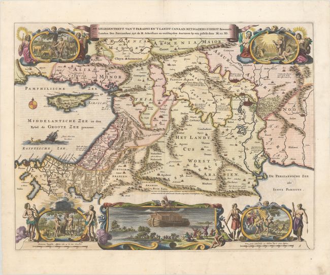
“De Gelegentheyt van 't Paradys en 't Landt Canaan, Mitsgaders d' eerst Bewoonde Landen der Patriarchen uyt de H. Schrifture…”
Map Maker:
Bastiaan Stoopendaal
This Dutch Bible map covers the region between the... (full text available to subscribers)
| Item Detail |
| |
| |
MapMaker: |
Bastiaan Stoopendaal
|
|
| |
| |
Subject: |
Middle East & Cyprus |
|
| |
Period/Size: |
1682 / 13.8" x 18.0" (35.1 x 45.8 cm)
|
|
| |
Color: |
Colored
|
|
| |
Condition: |
(A) A crisp impression on watermarked paper with a bit of faint foxing, some light creasing in the top corners, and a couple short centerfold separations confined to the blank margins. (condition help) |
|
| |
Source: |
|
|
| |
References: |
Poortman & Augusteijn #131 GI. |
|
| |
|
|
| Sales Information |
| |
| |
Price: |
|
|
| |
| |
Offered by: |
Old World Auctions |
|
| |
Catalog: |
Auction No. 187 - Antique Maps, Charts, Atlases & Globes (9557) |
|
| |
Lot/Item #: |
569 |
|
| |
| |
Date: |
02/2022
|
|
| |
| |
|
Antique Maps - Valuation and Pricing, Descriptions, Resources |
|
Home |
Information |
Search |
Register |
Contact Us |
Site Map
Americana Exchange, Inc. © 1999 - 2024 Americana Exchange, Inc.. All rights reserved.
OldMaps.com, the OldMaps.com logo and
AMPR are service marks or registered service marks of Americana Exchange, Inc..
|