Title:
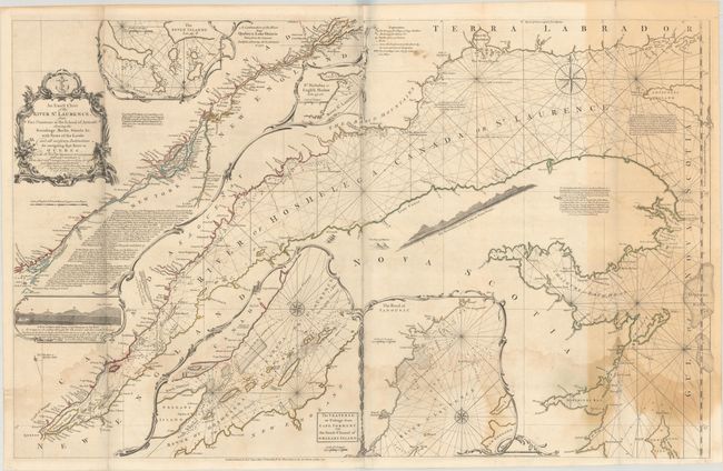
“An Exact Chart of the River St. Laurence, from Fort Frontenac to the Island of Anticosti Shewing the Soundings, Rocks, Shoals &c with Views of the Lands and All Necessary Instructions for Navigating that River to Quebec...”
Map Maker:
Jefferys/Sayer
This large-scale map of the St. Lawrence River was... (full text available to subscribers)
| Item Detail |
| |
| |
MapMaker: |
Jefferys/Sayer
|
|
| |
| |
Subject: |
St. Lawrence River |
|
| |
Period/Size: |
1771 / 23.6" x 37.0" (60.0 x 94.0 cm)
|
|
| |
Color: |
Colored
|
|
| |
Condition: |
(B) A crisp impression with contemporary outline color, issued folding with small holes at fold intersections and a few tiny wormholes in the image. There is dampstaining along the bottom of the map and light toning at right. (condition help) |
|
| |
Source: |
A General Atlas |
|
| |
References: |
Kershaw #668; Stevens & Tree #76-c. |
|
| |
|
|
| Sales Information |
| |
| |
Price: |
|
|
| |
| |
Offered by: |
Old World Auctions |
|
| |
Catalog: |
Auction No. 187 - Antique Maps, Charts, Atlases & Globes (9557) |
|
| |
Lot/Item #: |
137 |
|
| |
| |
Date: |
02/2022
|
|
| |
| |
|
Antique Maps - Valuation and Pricing, Descriptions, Resources |
|
Home |
Information |
Search |
Register |
Contact Us |
Site Map
Americana Exchange, Inc. © 1999 - 2024 Americana Exchange, Inc.. All rights reserved.
OldMaps.com, the OldMaps.com logo and
AMPR are service marks or registered service marks of Americana Exchange, Inc..
|