Title:
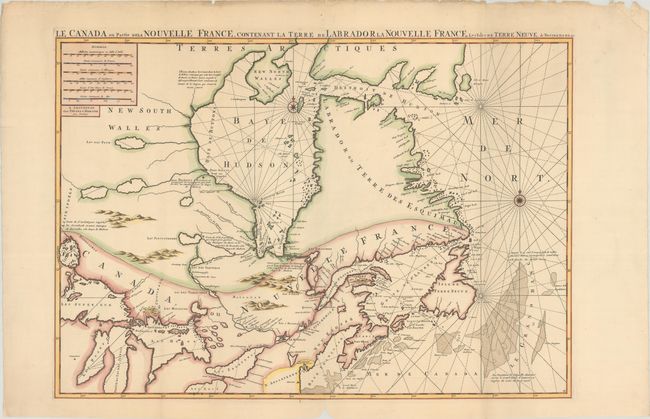
“Le Canada ou Partie de la Nouvelle France, Contenant la Terre de Labrador la Nouvelle France, les Isles de Terre Neuve, de Nostre Dame &c:”
Map Maker:
Jean Covens & Corneille Mortier
This large, striking map focuses on the region to ... (full text available to subscribers)
| Item Detail |
| |
| |
MapMaker: |
Jean Covens & Corneille Mortier
|
|
| |
| |
Subject: |
Eastern Canada, Great Lakes |
|
| |
Period/Size: |
1700 / 21.6" x 30.9" (54.9 x 78.5 cm)
|
|
| |
Color: |
Colored
|
|
| |
Condition: |
(A) A sharp impression on a bright sheet with a "P" watermark, issued folding with a hint of toning, some soiling and chipping along the top edge of the sheet, and a chip in the bottom margin along the centerfold. (condition help) |
|
| |
Source: |
Le Neptune Francois... |
|
| |
References: |
Kershaw #176.II; Verner & Stuart Stubbs, #9. |
|
| |
|
|
| Sales Information |
| |
| |
Price: |
|
|
| |
| |
Offered by: |
Old World Auctions |
|
| |
Catalog: |
Auction No. 187 - Antique Maps, Charts, Atlases & Globes (9557) |
|
| |
Lot/Item #: |
113 |
|
| |
| |
Date: |
02/2022
|
|
| |
| |
|
Antique Maps - Valuation and Pricing, Descriptions, Resources |
|
Home |
Information |
Search |
Register |
Contact Us |
Site Map
Americana Exchange, Inc. © 1999 - 2024 Americana Exchange, Inc.. All rights reserved.
OldMaps.com, the OldMaps.com logo and
AMPR are service marks or registered service marks of Americana Exchange, Inc..
|