Title:
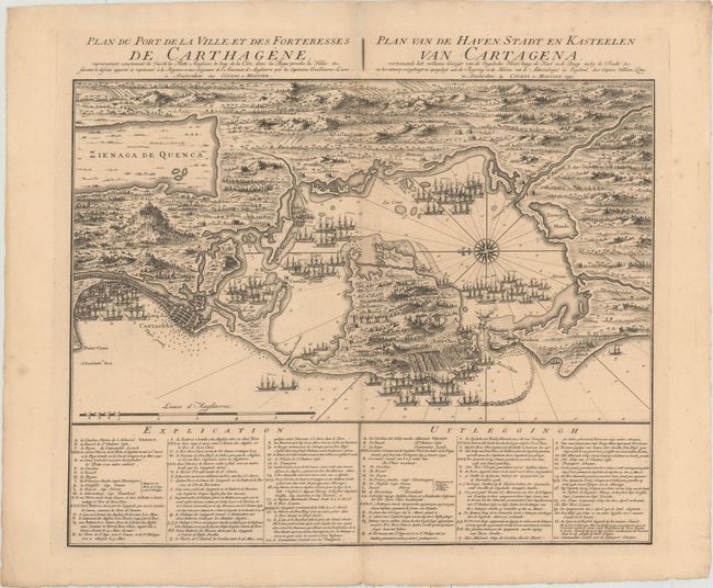
“Plan du Port de la Ville, et des Forteresses de Carthagene... / Plan van de Haven, Stadt en Kasteelen van Cartagena...”
Map Maker:
Jean Covens & Corneille Mortier
This superb broadsheet-style plan shows the Englis... (full text available to subscribers)
| Item Detail |
| |
| |
MapMaker: |
Jean Covens & Corneille Mortier
|
|
| |
| |
Subject: |
Cartagena, Colombia |
|
| |
Period/Size: |
1741 / 17.8" x 22.4" (45.3 x 56.9 cm)
|
|
| |
Color: |
Black & White
|
|
| |
Condition: |
(A) A crisp impression on sturdy paper with minor soiling along the centerfold and in the blank margins. There are some tiny chips and tears along the edges of the sheet. (condition help) |
|
| |
Source: |
Atlas Nouveau, Contenant Toutes les Parties du Monde... |
|
| |
References: |
Kapp (MCC-77) #75. |
|
| |
|
|
| Sales Information |
| |
| |
Price: |
|
|
| |
| |
Offered by: |
Old World Auctions |
|
| |
Catalog: |
Auction No. 187 - Antique Maps, Charts, Atlases & Globes (9557) |
|
| |
Lot/Item #: |
335 |
|
| |
| |
Date: |
02/2022
|
|
| |
| |
|
Antique Maps - Valuation and Pricing, Descriptions, Resources |
|
Home |
Information |
Search |
Register |
Contact Us |
Site Map
Americana Exchange, Inc. © 1999 - 2024 Americana Exchange, Inc.. All rights reserved.
OldMaps.com, the OldMaps.com logo and
AMPR are service marks or registered service marks of Americana Exchange, Inc..
|