Title:
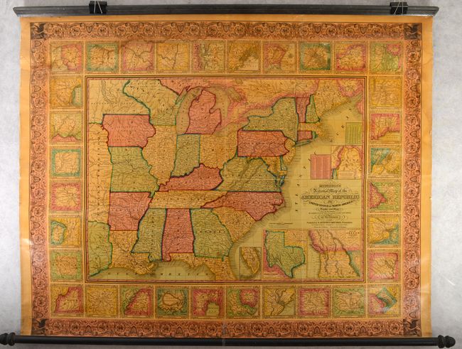
“Mitchell's National Map of the American Republic or United States of North America. Together with Maps of the Vicinities of Thirty-Two of the Principal Cities and Towns in the Union”
Map Maker:
Mitchell/Young
This is a very nice wall map that was drawn by J.H... (full text available to subscribers)
| Item Detail |
| |
| |
MapMaker: |
Mitchell/Young
|
|
| |
| |
Subject: |
Eastern United States |
|
| |
Period/Size: |
1847 / 37.6" x 47.6" (95.5 x 120.9 cm)
|
|
| |
Color: |
Colored
|
|
| |
Condition: |
(B) The map is mostly very clean and bright with some light dampstains along the top border and upper right border. There are 6" and 2" tears at top that have been backed with archival tape for stabilization. Original rollers are present and attached. (condition help) |
|
| |
Source: |
|
|
| |
References: |
|
|
| |
|
|
| Sales Information |
| |
| |
Price: |
|
|
| |
| |
Offered by: |
Old World Auctions |
|
| |
Catalog: |
Auction No. 187 - Antique Maps, Charts, Atlases & Globes (9557) |
|
| |
Lot/Item #: |
162 |
|
| |
| |
Date: |
02/2022
|
|
| |
| |
|
Antique Maps - Valuation and Pricing, Descriptions, Resources |
|
Home |
Information |
Search |
Register |
Contact Us |
Site Map
Americana Exchange, Inc. © 1999 - 2024 Americana Exchange, Inc.. All rights reserved.
OldMaps.com, the OldMaps.com logo and
AMPR are service marks or registered service marks of Americana Exchange, Inc..
|