Title:
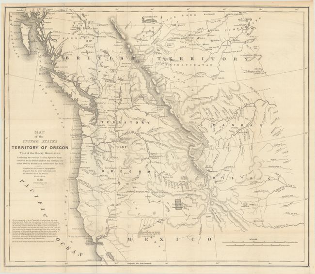
“Map of the United States Territory of Oregon West of the Rocky Mountains, Exhibiting the Various Trading Depots or Forts...”
Map Maker:
Albert/Hood
This map was issued in an important report intende... (full text available to subscribers)
| Item Detail |
| |
| |
MapMaker: |
Albert/Hood
|
|
| |
| |
Subject: |
Northwestern United States |
|
| |
Period/Size: |
1838 / 17.4" x 20.3" (44.2 x 51.6 cm)
|
|
| |
Color: |
Black & White
|
|
| |
Condition: |
(B+) Issued folding on a clean sheet with two 3" edge tears at left that have been archivally repaired on verso. (condition help) |
|
| |
Source: |
|
|
| |
References: |
Wheat (TMW) #434; Claussen & Friis #221. |
|
| |
|
|
| Sales Information |
| |
| |
Price: |
|
|
| |
| |
Offered by: |
Old World Auctions |
|
| |
Catalog: |
Auction No. 187 - Antique Maps, Charts, Atlases & Globes (9557) |
|
| |
Lot/Item #: |
207 |
|
| |
| |
Date: |
02/2022
|
|
| |
| |
|
Antique Maps - Valuation and Pricing, Descriptions, Resources |
|
Home |
Information |
Search |
Register |
Contact Us |
Site Map
Americana Exchange, Inc. © 1999 - 2024 Americana Exchange, Inc.. All rights reserved.
OldMaps.com, the OldMaps.com logo and
AMPR are service marks or registered service marks of Americana Exchange, Inc..
|