Title:
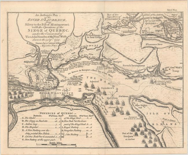
“An Authentic Plan of the River St. Laurence, from Sillery to the Fall of Montmerenci, with the Operations of the Siege of Quebec, Under the Command of Vice-Adml. Saunders & Majr. Genl. Wolfe...”
Map Maker:
anonymous
This scarce map details the 1759 Battle of Quebec ... (full text available to subscribers)
| Item Detail |
| |
| |
MapMaker: |
anonymous
|
|
| |
| |
Subject: |
Quebec, Canada |
|
| |
Period/Size: |
1759 / 7.4" x 9.4" (18.8 x 23.9 cm)
|
|
| |
Color: |
Black & White
|
|
| |
Condition: |
(A) Issued folding on watermarked paper with minor offsetting from an opposing page of text. (condition help) |
|
| |
Source: |
Royal Magazine |
|
| |
References: |
Jolly #ROYMAG-6. |
|
| |
|
|
| Sales Information |
| |
| |
Price: |
|
|
| |
| |
Offered by: |
Old World Auctions |
|
| |
Catalog: |
Auction No. 187 - Antique Maps, Charts, Atlases & Globes (9557) |
|
| |
Lot/Item #: |
120 |
|
| |
| |
Date: |
02/2022
|
|
| |
| |
|
Antique Maps - Valuation and Pricing, Descriptions, Resources |
|
Home |
Information |
Search |
Register |
Contact Us |
Site Map
Americana Exchange, Inc. © 1999 - 2024 Americana Exchange, Inc.. All rights reserved.
OldMaps.com, the OldMaps.com logo and
AMPR are service marks or registered service marks of Americana Exchange, Inc..
|