Title:
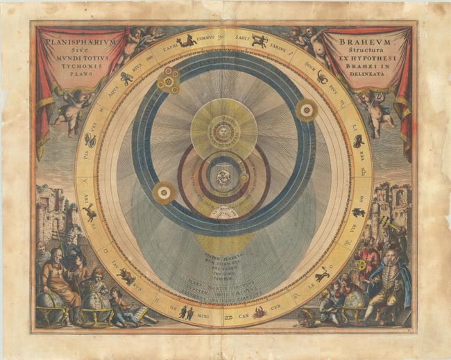
“Planisphaerium Braheum, sive Structura Mundi Totius, Ex Hypothesi Tychonis Brahei in Plano Descriptio”
Map Maker:
Andreas Cellarius
A handsome chart depicting Tycho Brahe's model of ... (full text available to subscribers)
| Item Detail |
| |
| |
MapMaker: |
Andreas Cellarius
|
|
| |
| |
Subject: |
Solar System |
|
| |
Period/Size: |
1661 / 16.6" x 20.4" (42.2 x 51.9 cm)
|
|
| |
Color: |
Colored
|
|
| |
Condition: |
(B) A fine impression on a lightly toned sheet backed with archival tissue to repair chipping in the blank margins and a few edge tears that enter the engraved image. There is some extraneous creasing around the centerfold and light soiling, much of it c (condition help) |
|
| |
Source: |
Atlas Coelestis seu Harmonia Macrocosmica |
|
| |
References: |
Kanas, pp. 191-94; Van der Krogt (Vol. I) #HM06:1. |
|
| |
|
|
| Sales Information |
| |
| |
Price: |
|
|
| |
| |
Offered by: |
Old World Auctions |
|
| |
Catalog: |
Auction No. 187 - Antique Maps, Charts, Atlases & Globes (9557) |
|
| |
Lot/Item #: |
52 |
|
| |
| |
Date: |
02/2022
|
|
| |
| |
|
Antique Maps - Valuation and Pricing, Descriptions, Resources |
|
Home |
Information |
Search |
Register |
Contact Us |
Site Map
Americana Exchange, Inc. © 1999 - 2024 Americana Exchange, Inc.. All rights reserved.
OldMaps.com, the OldMaps.com logo and
AMPR are service marks or registered service marks of Americana Exchange, Inc..
|