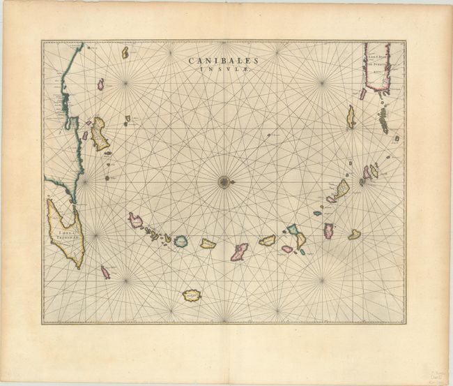
Title:
“Canibales Insulae”
Map Maker:
Johannes Blaeu
This is the first Dutch map to focus on the Lesser... (full text available to subscribers)
| Item Detail |
| |
| |
MapMaker: |
Johannes Blaeu
|
|
| |
| |
Subject: |
Lesser Antilles |
|
| |
Period/Size: |
1663 / 16.4" x 21.0" (41.7 x 53.4 cm)
|
|
| |
Color: |
Colored
|
|
| |
Condition: |
(A) On a watermarked sheet with the Greek god Atlas. There is a very faint dampstain at bottom that just touches the border. (condition help) |
|
| |
Source: |
Le Grand Atlas... |
|
| |
References: |
Goss (Blaeu) #70; Van der Krogt (Vol. II) 9640:2. |
|
| |
|
|
| Sales Information |
| |
| |
Price: |
|
|
| |
| |
Offered by: |
Old World Auctions |
|
| |
Catalog: |
Auction No. 188 - Antique Maps, Charts, Atlases & Globes (9558) |
|
| |
Lot/Item #: |
284 |
|
| |
| |
Date: |
04/2022
|
|
| |
| |
|
Antique Maps - Valuation and Pricing, Descriptions, Resources |
|
Home |
Information |
Search |
Register |
Contact Us |
Site Map
Americana Exchange, Inc. © 1999 - 2024 Americana Exchange, Inc.. All rights reserved.
OldMaps.com, the OldMaps.com logo and
AMPR are service marks or registered service marks of Americana Exchange, Inc..
|