Title:
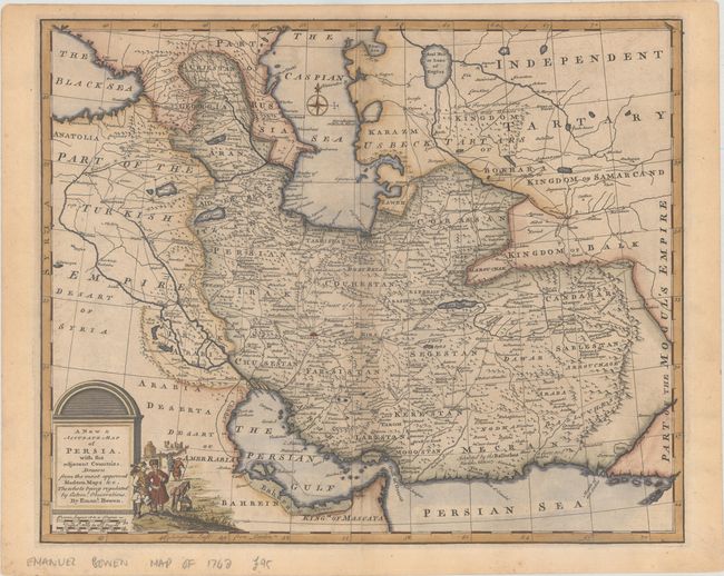
“A New & Accurate Map of Persia, with the Adjacent Countries. Drawn from the Most Approved Modern Maps &c. The Whole Being Regulated by Astronl. Observations”
Map Maker:
Emanuel Bowen
This fine map of the Persian Empire is packed with... (full text available to subscribers)
| Item Detail |
| |
| |
MapMaker: |
Emanuel Bowen
|
|
| |
| |
Subject: |
Persia - Iran |
|
| |
Period/Size: |
1766 / 13.7" x 16.8" (34.8 x 42.7 cm)
|
|
| |
Color: |
Colored
|
|
| |
Condition: |
(B+) A sharp impression on a sheet with a fleur-de-lis watermark. There is pleasant light toning and minor offsetting. (condition help) |
|
| |
Source: |
The Maps and Charts to the Modern Part of the Universal History |
|
| |
References: |
cf. McCorkle (18th C. Geography Books) #17-8 (Vol II); Shirley (BL Atlases) T.BOW-2d #25. |
|
| |
|
|
| Sales Information |
| |
| |
Price: |
|
|
| |
| |
Offered by: |
Old World Auctions |
|
| |
Catalog: |
Auction No. 188 - Antique Maps, Charts, Atlases & Globes (9558) |
|
| |
Lot/Item #: |
622 |
|
| |
| |
Date: |
04/2022
|
|
| |
| |
|
Antique Maps - Valuation and Pricing, Descriptions, Resources |
|
Home |
Information |
Search |
Register |
Contact Us |
Site Map
Americana Exchange, Inc. © 1999 - 2024 Americana Exchange, Inc.. All rights reserved.
OldMaps.com, the OldMaps.com logo and
AMPR are service marks or registered service marks of Americana Exchange, Inc..
|