Title:
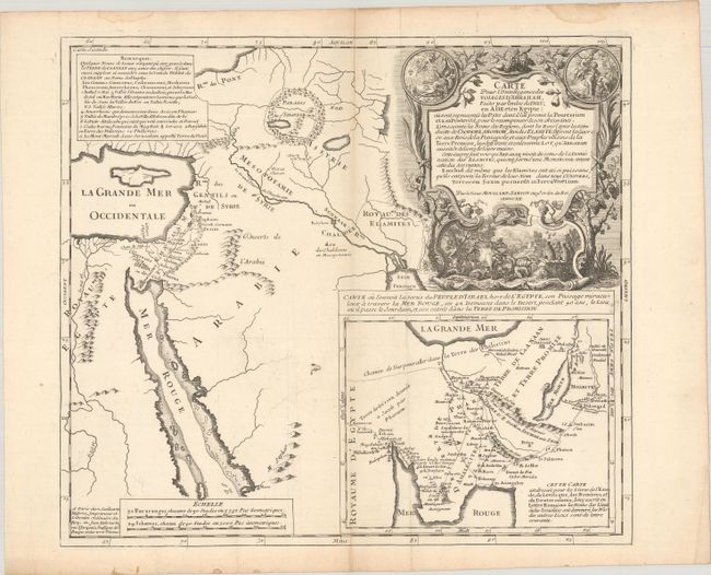
“Carte pour l'Intelligence des Voiages d'Abraham, Faits par l'Ordre de Dieu, en Asie et en Egypte...”
Map Maker:
Moullart-Sanson
This fascinating historical map shows the Holy Lan... (full text available to subscribers)
| Item Detail |
| |
| |
MapMaker: |
Moullart-Sanson
|
|
| |
| |
Subject: |
Holy Land |
|
| |
Period/Size: |
1712 / 14.1" x 15.9" (35.9 x 40.4 cm)
|
|
| |
Color: |
Black & White
|
|
| |
Condition: |
(B+) Issued folding with very light offsetting and soiling, extraneous creasing, and some toning along the central fold. There are some dampstains along the edges of the sheet, well away from the image. (condition help) |
|
| |
Source: |
|
|
| |
References: |
|
|
| |
|
|
| Sales Information |
| |
| |
Price: |
|
|
| |
| |
Offered by: |
Old World Auctions |
|
| |
Catalog: |
Auction No. 188 - Antique Maps, Charts, Atlases & Globes (9558) |
|
| |
Lot/Item #: |
614 |
|
| |
| |
Date: |
04/2022
|
|
| |
| |
|
Antique Maps - Valuation and Pricing, Descriptions, Resources |
|
Home |
Information |
Search |
Register |
Contact Us |
Site Map
Americana Exchange, Inc. © 1999 - 2024 Americana Exchange, Inc.. All rights reserved.
OldMaps.com, the OldMaps.com logo and
AMPR are service marks or registered service marks of Americana Exchange, Inc..
|