Title:
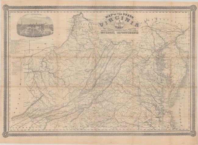
“Map of the State of Virginia Containing the Counties, Principal Towns, Railroads Rivers, Canals & All Other Internal Improvements”
This is the first edition of this rare map of Virg... (full text available to subscribers)
| Item Detail |
| |
| |
MapMaker: |
(none given)
|
|
| |
| |
Subject: |
Virginia, Civil War |
|
| |
Period/Size: |
1862 / 25.6" x 37.4" (65.1 x 95.0 cm)
|
|
| |
Color: |
Black & White
|
|
| |
Condition: |
(B+) Issued folding and now flattened and professionally backed with tissue to reinforce and repair numerous fold separations. There is some minor loss at several fold junctions and a few spots of foxing in the image. Accompanying covers are worn and so (condition help) |
|
| |
Source: |
|
|
| |
References: |
Stephenson (Civil War) #475.5; Wooldridge #254. |
|
| |
|
|
| Sales Information |
| |
| |
Price: |
|
|
| |
| |
Offered by: |
Old World Auctions |
|
| |
Catalog: |
Auction No. 188 - Antique Maps, Charts, Atlases & Globes (9558) |
|
| |
Lot/Item #: |
249 |
|
| |
| |
Date: |
04/2022
|
|
| |
| |
|
Antique Maps - Valuation and Pricing, Descriptions, Resources |
|
Home |
Information |
Search |
Register |
Contact Us |
Site Map
Americana Exchange, Inc. © 1999 - 2024 Americana Exchange, Inc.. All rights reserved.
OldMaps.com, the OldMaps.com logo and
AMPR are service marks or registered service marks of Americana Exchange, Inc..
|