Title:
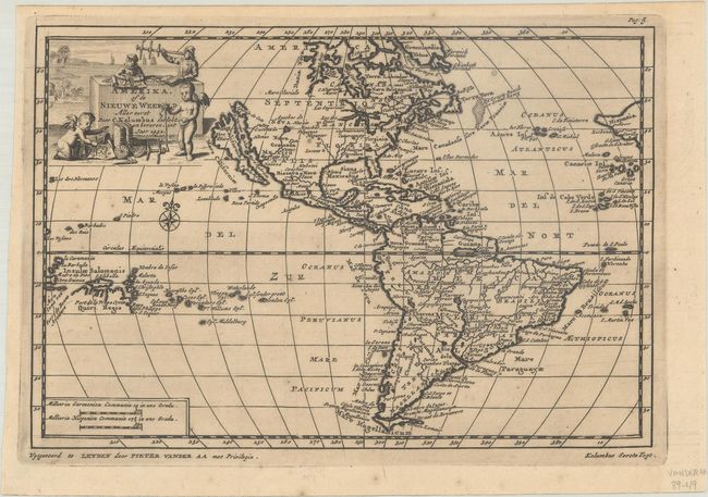
“Amerika, of de Nieuwe Weerld Aller eerst door C. Kolumbus Ontdekt, en Bevaren, int Jaar 1492”
Map Maker:
Pieter van der Aa
Charming map of the Americas with California as... (full text available to subscribers)
| Item Detail |
| |
| |
MapMaker: |
Pieter van der Aa
|
|
| |
| |
Subject: |
Western Hemisphere - America |
|
| |
Period/Size: |
1706 / 6.0" x 8.9" (15.3 x 22.6 cm)
|
|
| |
Color: |
Black & White
|
|
| |
Condition: |
(B+) A dark impression, issued folding with minor of toning and a few small spots of foxing. (condition help) |
|
| |
Source: |
Cartes de Itineraires & Voyages Modernes |
|
| |
References: |
McLaughlin #168. |
|
| |
|
|
| Sales Information |
| |
| |
Price: |
|
|
| |
| |
Offered by: |
Old World Auctions |
|
| |
Catalog: |
Auction No. 188 - Antique Maps, Charts, Atlases & Globes (9558) |
|
| |
Lot/Item #: |
62 |
|
| |
| |
Date: |
04/2022
|
|
| |
| |
|
Antique Maps - Valuation and Pricing, Descriptions, Resources |
|
Home |
Information |
Search |
Register |
Contact Us |
Site Map
Americana Exchange, Inc. © 1999 - 2024 Americana Exchange, Inc.. All rights reserved.
OldMaps.com, the OldMaps.com logo and
AMPR are service marks or registered service marks of Americana Exchange, Inc..
|