Title:
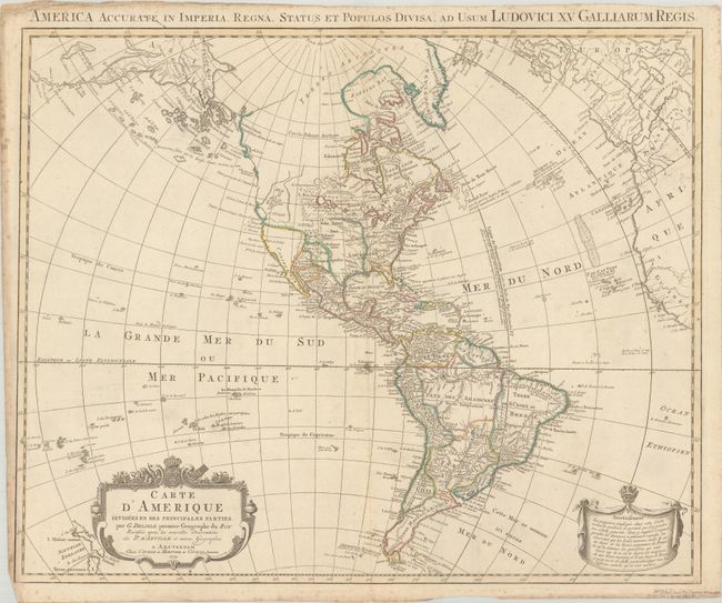
“Carte d'Amerique Divisees en ses Principales Parties, par G. Delisle, Premier Geographe du Roy...”
Map Maker:
Delisle/Covens & Mortier
This map depicts a fascinating stage in the cartog... (full text available to subscribers)
| Item Detail |
| |
| |
MapMaker: |
Delisle/Covens & Mortier
|
|
| |
| |
Subject: |
Western Hemisphere - America |
|
| |
Period/Size: |
1774 / 19.3" x 23.8" (49.1 x 60.5 cm)
|
|
| |
Color: |
Colored
|
|
| |
Condition: |
(B+) Contemporary outline color on "C&I Honig" watermarked paper with faint foxing along the centerfold and light foxing in the blank margins. There is some minor creasing along the sheet edges. (condition help) |
|
| |
Source: |
|
|
| |
References: |
McGuirk #153; Tooley (Amer) p. 17, #20. |
|
| |
|
|
| Sales Information |
| |
| |
Price: |
|
|
| |
| |
Offered by: |
Old World Auctions |
|
| |
Catalog: |
Auction No. 188 - Antique Maps, Charts, Atlases & Globes (9558) |
|
| |
Lot/Item #: |
70 |
|
| |
| |
Date: |
04/2022
|
|
| |
| |
|
Antique Maps - Valuation and Pricing, Descriptions, Resources |
|
Home |
Information |
Search |
Register |
Contact Us |
Site Map
Americana Exchange, Inc. © 1999 - 2024 Americana Exchange, Inc.. All rights reserved.
OldMaps.com, the OldMaps.com logo and
AMPR are service marks or registered service marks of Americana Exchange, Inc..
|