Title:
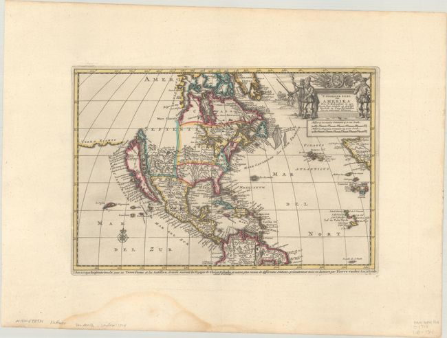
“'T Noorder deel van Amerika door. C. Kolumbus in zyn Eerste togt Ontdekt en Desselfs Kusten en Voor-Eylanden een en Andermaal Bevaaren”
Map Maker:
Pieter van der Aa
This charming map depicts a large island of Cal... (full text available to subscribers)
| Item Detail |
| |
| |
MapMaker: |
Pieter van der Aa
|
|
| |
| |
Subject: |
Colonial North America |
|
| |
Period/Size: |
1707 / 7.9" x 11.8" (20.1 x 30.0 cm)
|
|
| |
Color: |
Colored
|
|
| |
Condition: |
(A) Contemporary outline color on a sheet with wide original margins and a fleur-de-lis watermark. A light dampstain is confined to the bottom blank margin. (condition help) |
|
| |
Source: |
Atlas Nouveau et Curieux des Plus Celebres Itineraires... |
|
| |
References: |
McLaughlin #172; Tooley (Amer) p. 129, #75. |
|
| |
|
|
| Sales Information |
| |
| |
Price: |
|
|
| |
| |
Offered by: |
Old World Auctions |
|
| |
Catalog: |
Auction No. 188 - Antique Maps, Charts, Atlases & Globes (9558) |
|
| |
Lot/Item #: |
73 |
|
| |
| |
Date: |
04/2022
|
|
| |
| |
|
Antique Maps - Valuation and Pricing, Descriptions, Resources |
|
Home |
Information |
Search |
Register |
Contact Us |
Site Map
Americana Exchange, Inc. © 1999 - 2024 Americana Exchange, Inc.. All rights reserved.
OldMaps.com, the OldMaps.com logo and
AMPR are service marks or registered service marks of Americana Exchange, Inc..
|