Title:
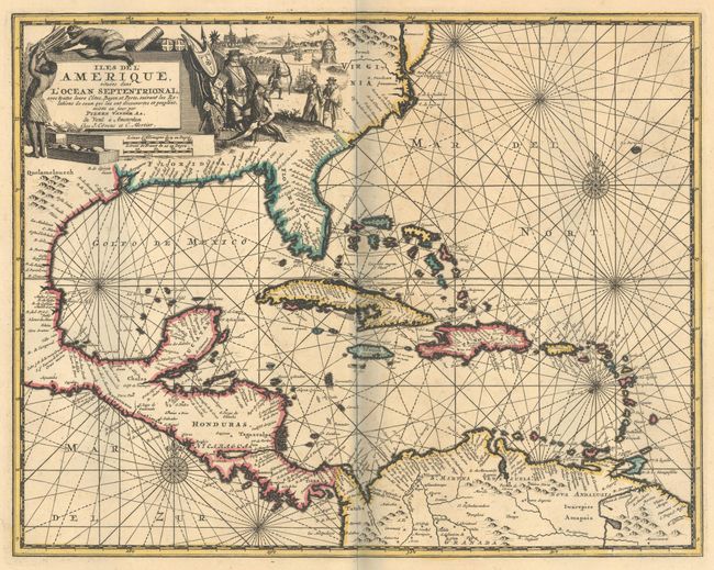
“Iles de l'Amerique, Situees dans l'Ocean Septentrional, avec Toutes Leurs Cotes, Bayes, et Ports, Suivant les Relations de Ceux qui les ont Decouvertes et Peuples...”
Map Maker:
Jean Covens & Corneille Mortier
This scarce and skillfully engraved map focuses on... (full text available to subscribers)
| Item Detail |
| |
| |
MapMaker: |
Jean Covens & Corneille Mortier
|
|
| |
| |
Subject: |
Gulf of Mexico & Caribbean |
|
| |
Period/Size: |
1735 / 11.1" x 14.1" (28.2 x 35.9 cm)
|
|
| |
Color: |
Colored
|
|
| |
Condition: |
(A) Contemporary outline color on a sturdy sheet with wide original margins. There is some minor foxing mostly in the blank margins. The faint shadow along the centerfold is caused by our scanner and is not present on the physical map. (condition help) |
|
| |
Source: |
|
|
| |
References: |
|
|
| |
|
|
| Sales Information |
| |
| |
Price: |
|
|
| |
| |
Offered by: |
Old World Auctions |
|
| |
Catalog: |
Auction No. 188 - Antique Maps, Charts, Atlases & Globes (9558) |
|
| |
Lot/Item #: |
269 |
|
| |
| |
Date: |
04/2022
|
|
| |
| |
|
Antique Maps - Valuation and Pricing, Descriptions, Resources |
|
Home |
Information |
Search |
Register |
Contact Us |
Site Map
Americana Exchange, Inc. © 1999 - 2024 Americana Exchange, Inc.. All rights reserved.
OldMaps.com, the OldMaps.com logo and
AMPR are service marks or registered service marks of Americana Exchange, Inc..
|