Title:
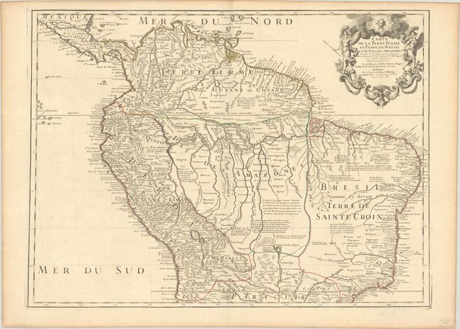
“Carte de la Terre Ferme du Perou, du Bresil et du Pays des Amazones Dressee sur les Descriptions de Herrera de Laet, et des PP. d'Acuna, et M. Rodriguez...”
Map Maker:
Guillaume Delisle
This handsome and important map of the northern pa... (full text available to subscribers)
| Item Detail |
| |
| |
MapMaker: |
Guillaume Delisle
|
|
| |
| |
Subject: |
Northern South America |
|
| |
Period/Size: |
1703 / 19.1" x 25.8" (48.6 x 65.6 cm)
|
|
| |
Color: |
Colored
|
|
| |
Condition: |
(A) A crisp impression with contemporary outline color on a bright sheet with the watermark of a large Maltese cross. There is faint offsetting, light toning along the edges of the sheet, and a short centerfold separation in the bottom blank margin. (condition help) |
|
| |
Source: |
|
|
| |
References: |
|
|
| |
|
|
| Sales Information |
| |
| |
Price: |
|
|
| |
| |
Offered by: |
Old World Auctions |
|
| |
Catalog: |
Auction No. 188 - Antique Maps, Charts, Atlases & Globes (9558) |
|
| |
Lot/Item #: |
302 |
|
| |
| |
Date: |
04/2022
|
|
| |
| |
|
Antique Maps - Valuation and Pricing, Descriptions, Resources |
|
Home |
Information |
Search |
Register |
Contact Us |
Site Map
Americana Exchange, Inc. © 1999 - 2024 Americana Exchange, Inc.. All rights reserved.
OldMaps.com, the OldMaps.com logo and
AMPR are service marks or registered service marks of Americana Exchange, Inc..
|