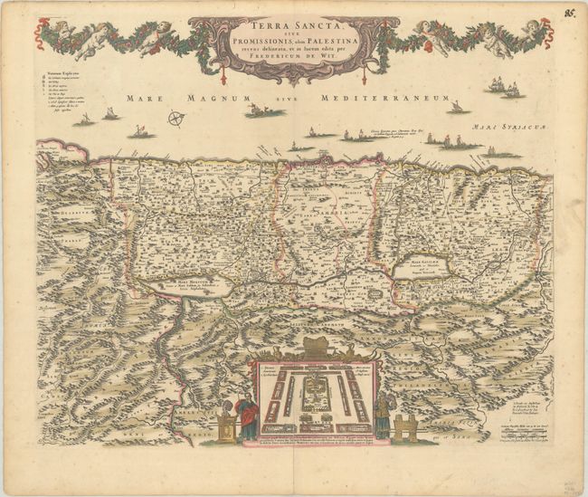
Title:
“Terra Sancta, sive Promissionis, olim Palestina Recens Delineata, et in Lucem Edita”
Map Maker:
Frederick de Wit
North is oriented to the right on this richly deco... (full text available to subscribers)
| Item Detail |
| |
| |
MapMaker: |
Frederick de Wit
|
|
| |
| |
Subject: |
Holy Land |
|
| |
Period/Size: |
1680 / 18.0" x 21.9" (45.8 x 55.7 cm)
|
|
| |
Color: |
Colored
|
|
| |
Condition: |
(B+) Full contemporary color on a sheet with a "P" watermark, minor foxing, and a centerfold separation at bottom that has been repaired on verso. (condition help) |
|
| |
Source: |
|
|
| |
References: |
Laor #860. |
|
| |
|
|
| Sales Information |
| |
| |
Price: |
|
|
| |
| |
Offered by: |
Old World Auctions |
|
| |
Catalog: |
Auction No. 188 - Antique Maps, Charts, Atlases & Globes (9558) |
|
| |
Lot/Item #: |
613 |
|
| |
| |
Date: |
04/2022
|
|
| |
| |
|
Antique Maps - Valuation and Pricing, Descriptions, Resources |
|
Home |
Information |
Search |
Register |
Contact Us |
Site Map
Americana Exchange, Inc. © 1999 - 2024 Americana Exchange, Inc.. All rights reserved.
OldMaps.com, the OldMaps.com logo and
AMPR are service marks or registered service marks of Americana Exchange, Inc..
|