Title:
“Annual Report of the United States Geological and Geographical Survey of the Territories, Embracing Colorado and Parts of Adjacent Territories...”
Map Maker:
Ferdinand Vandeveer Hayden
This is the eighth annual report of the Geological... (full text available to subscribers)
| Item Detail |
| |
| |
MapMaker: |
Ferdinand Vandeveer Hayden
|
|
| |
| |
Subject: |
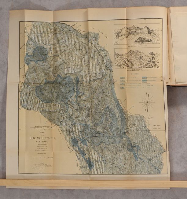
Colorado |
|
| |
Period/Size: |
1876 / 9.3" x 6.0" (23.7 x 15.3 cm)
|
|
| |
Color: |
Colored
|
|
| |
Condition: |
(B+) The contents are clean with uniform light toning. The Eastern Base of the Rockies map has a couple of small holes in the upper third of the image (B). There is a blank bookplate on the front pastedown, and the covers have light wear with a small pi (condition help) |
|
| |
Source: |
|
|
| |
References: |
|
|
| |
|
|
| Sales Information |
| |
| |
Price: |
|
|
| |
| |
Offered by: |
Old World Auctions |
|
| |
Catalog: |
Auction No. 188 - Antique Maps, Charts, Atlases & Globes (9558) |
|
| |
Lot/Item #: |
208 |
|
| |
| |
Date: |
04/2022
|
|
| |
| |
|
Antique Maps - Valuation and Pricing, Descriptions, Resources |
|
Home |
Information |
Search |
Register |
Contact Us |
Site Map
Americana Exchange, Inc. © 1999 - 2024 Americana Exchange, Inc.. All rights reserved.
OldMaps.com, the OldMaps.com logo and
AMPR are service marks or registered service marks of Americana Exchange, Inc..
|